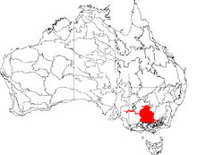
Riverina
The Riverina is distinguished from other Australian regions by the combination of flat plains, warm to hot climate and an ample supply of water for irrigation.
Home to Aboriginal groups including the Wiradjuri people for over 40,000 years, the Riverina was colonised by Europeans in the mid-19th century as a pastoral region providing beef and wool to markets in Australia and beyond.
In the 20th century, the development of major irrigation areas in the Murray and Murrumbidgee valleys has led to the introduction of crops such as rice and wine grapes.
[6] In common usage the Riverina generally comprises the agricultural and pastoral areas of New South Wales, west of the Great Dividing Range and in the drainage basin of the snow-fed Murray and Murrumbidgee Rivers.
[8][9] Riverina soils are generally sandy along the river channels, with more saline grey and brown clays found on rarely flooded areas on the perimeter of the floodplain.
[23] In another mapping the World Wildlife Fund has made this area part of the larger Southeast Australia temperate savanna ecoregion that covers the western plains of New South Wales.
Competition from introduced species and the effect of clearing, grazing and pasture improvement has led to a decline in the diversity of native flora and fauna in the area.
[28] Other groups living along the Murrumbidgee included the Nari-Nari on the western plains where the town of Hay,[29] the Muthi-Muthi along the Lowbidgee, Gurendji and the Yida-Yida of Oxley.
[26] Oxley was followed by Charles Sturt, who followed the Murrumbidgee downstream to Lake Alexandrina in South Australia between 1828 and 1831[31] and Major Thomas Mitchell in 1836 on his way to the Wimmera and the Western District.
Messrs Watt & Thomson, the owners of an adjoining property, "North Urana", subsequently purchased "Cocketgedong" from Brock & Hardie, giving them a total area of approximately 65,000 acres.
In the Narrandera district, a battle took place between settlers and the local Narrungderra clan at a location now known as Massacre Island, reportedly leaving only one survivor.
[42][43] Soon after the movement fell apart due to the differences between the squatters on one side and the small farmers and townspeople on the other causing its objectives to become obscured by other associated issues such as inter-colonial tariffs and rail links.
[42] From 1853, the Riverina was linked to markets through a series of riverboats along the Murray and Murrumbidgee to the river ports of Mannum and Goolwa in South Australia[45][46] and from 1864, to Echuca connected by rail to Melbourne.
[23][35][44][48] The riverboat era peaked in the twenty years from 1870 to 1890, declining with the coming of the railway and finally ending with the disruption to the workforce caused by World War I.
[57] Transport links assisted the development of the Riverina economy, at the same time areas of the region found themselves under threat from robbery and murder by various bushrangers.
Having previously been convicted of armed robbery, Morgan came to the attention to authorities in the Riverina when he bailed up a police magistrate, Henry Baylis, near Urana in 1863.
After riding overland from north east Victoria, Kelly and his gang in a brazen move captured two local policemen and stole their uniforms.
Along the Riverina the Murray was—and remains—part of New South Wales, who had no interest in assisting border residents to access goods and services in Victoria that may otherwise have been sourced from Sydney.
[60] Following a series of addresses by the future Prime Minister, Edmund Barton to large crowds, some 15 League branches were established in the towns along the southern border.
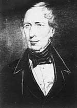
At this conference, Dr John Quick, a delegate from Bendigo, proposed a resolution calling for the colonial legislatures to pass an act providing for the election of representatives to a convention to develop a federal constitution.
[26] Development and promotion of the MIA led to large scale settlement on land described by Oxley 100 years earlier as "country which, for barrenness and desolation, can I think, have no equal."
[68] The first commercial rice crops in the Riverina were grown in the Leeton and Yanco district in 1924, expanding to Wakool during World War II, the Denimein and Deniboota Irrigation Areas in the 1950s and Coleambally and Finley in the 1960s.
The Riverina GI is centred on Griffith and is roughly circular with towns on the boundary including Mossgiel, Condobolin, Temora, Junee, Culcairn, Berrigan, Finley, Deniliquin and Moulamein.
[86] There are a range of local government authorities in the region, ranging from the cities of Wagga Wagga and Griffith; to the municipalities of Edward River, Federation, Cootamundra-Gundagai, Murray River, Murrumbidgee and Snowy Valleys; and the shires of Balranald, Berrigan, Carrathool, Coolamon, Greater Hume, Hay, Junee, Leeton, Lockhart, Narrandera, Bland and Temora.
NSW TrainLink rail services from Sydney to Griffith and Melbourne serve the Riverina with connecting buses reaching smaller communities.
These include: The "Wagga Effect" is a term that has been used frequently in the Australian media to describe the disproportionately large number of elite sportsmen and women that originate from the town.
The Riverina is home to many racecourses and picnic race meetings are held regularly at places such as Corowa, Berrigan, Carrathool, Tumut and Lockhart.
Most of these works reflected the rural lifestyle and agricultural pursuits common in the Riverina at that time and projected an image of Australia and Australians that would later change rapidly.
[104] Later, using the pen name Tom Collins, Furphy wrote Such Is Life set in the Riverina during the drought and depression of the 1890s and drawing on his experiences as a bullocky.
[106] The artist and key member of the Heidelberg School, Tom Roberts spent some time on a sheep station near Brocklesby prior to and during the painting of his most celebrated artwork, Shearing the Rams.