Carabane
Since World War II, the population of the island has gradually declined for a variety of reasons including periods of drought, the Casamance Conflict and, more recently, the sinking of the ferry Joola in 2002.
Although Carabane was once a regional capital, the village has since become so politically isolated from the rest of the country that it no longer fits into any category of the administrative structure decreed by the Senegalese government.
The indigenous population was originally animist, but although the sacred groves and fetishes survive as cultural icons of Casamance, the monotheistic belief systems of Catholicism and Islam have become the most widely held in Carabane.
The testimonies of explorers and colonial administrators demonstrate that Carabane has participated in rice cultivation, fishery, trade, and palm wine production for a long time.
[4] While this adage continues to hold true, it was even more appropriate in the 19th century when, according to one traveller, a 26-hour boat trip from Rufisque (near Dakar) to Carabane was deemed fairly short, and was credited to a favourable wind.
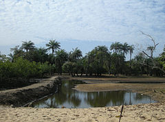
As pointed out by early French observers, soils in the region are generally composed of sand and clay, differing in mixture and layer according to natural and human factors.
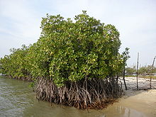
[11] In this flat and marshy area, the branches and roots of mangrove trees form dams where deposits of oyster shells naturally accumulate along with mud and plant detritus.
A study in 1998 discovered the following species on the island: African darter (Anhinga rufa), Goliath heron (Ardea goliath), palm-nut vulture (Gypohierax angolensis), black-tailed godwit (Limosa limosa), whimbrel (Numenius phaeopus), Eurasian curlew (Numenius arquata), Caspian tern (Sterna caspia), blue-spotted wood-dove (Turtur afer), red-eyed dove (Streptopelia semitorquata), white-rumped swift (Apus caffer), woodland kingfisher (Halcyon senegalensis), grey-backed camaroptera (Camaroptera brachyura), red-bellied paradise-flycatcher (Terpsiphone rufiventer), pied crow (Corvus albus), black-rumped waxbill (Estrilda troglodytes) and yellow-fronted canary (Serinus mozambicus).
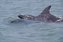
In this way, the nearby Basse Casamance National Park, which has been closed for years, has seen a remarkable return of Nile crocodiles (Crocodylus niloticus), Senegalese manatees (Trichechus senegalensis), and breeding birds.
The Baudin family used slaves to produce the rice and, despite the declaration of its official abolition in the French colonial empire in 1848, slavery continued on the island until the early 20th century.
[47][48] The colonial administration wanted to expand its influence around the river, particularly because the inhabitants of Gorée were threatened with losing part of their resources with the imminent demise of the slave trade, and also because of their competition with Saint-Louis.
[50] Still, another treaty made Sédhiou the primary trading post of Casamance, and the exploitation of Carabane was left for some time in the hands of the Baudin family, first Pierre then his brother Jean.
Carabane exported rice, but also cotton, considered to be of poor quality,[54] which was ginned in a factory built by Bertrand-Bocandé in 1840, owned first by Maurel & Prom and then by the Casamance Company.
While the Mandinka Muslims continued, illegally, to practice slavery and trade, non-Muslim villages tended to come together, accepting the Resident of Carabane as the arbitrator of their disagreements.
[66] Despite the anti-clerical movement's growth in France at the time, education in Carabane continued to be administered by the Holy Ghost Fathers for the boys and by the Sisters of St. Joseph of Cluny for the girls.
The thirteen churches were located in Dakar, Saint-Louis, Gorée, Rufisque, Thiès, Ngazobil, Joal, Fadiouth, Foundiougne, Kaolack, Ziguinchor, Bignona and Banjul.
[69] In taking leadership of the diocese, Archbishop Le Hunsec noted that the island of Carabane, heavily populated when trading was concentrated there, had lost its influence and now had fewer than 500 inhabitants.
[71] A report submitted in 1938 by an educational advisor to Marcel de Coppet, Governor General of French West Africa, detailed the daily life of the prisoners in the school which housed up to 22 boys, mostly convicted for theft but also occasionally for murder.
[77] The ceasefire of 2004 brought relative peace, but in the meantime, the sinking of the Joola in 2002 claimed the lives of many inhabitants of Carabane and curtailed much of its ability to engage in trade and accept tourists for several years.
[79] Formerly an administrative district in its own right,[note 3] even a regional capital, Carabane is now just one of 23 villages in the rural community of Diembéring, of which Kabrousse, Cap Skirring, and Boucott-Diembéring are the largest centres.
Other specialists, such as Christian Sina Diatta, compare Jola communities to those of mound-building termites, in which each member performs a specific function and where the queen is easily replaceable.
[91] The indigenous population was originally animist, but while the fetishes and sacred groves dedicated to initiation rites such as boukout survive as cultural icons of Casamance,[92] the monotheistic belief systems of Catholicism and Islam have become the most widely held in Carabane.
[100] The island experienced a decline in the 20th century, when Ziguinchor emerged as the regional capital, and more recently because of the negative economic consequences resulting from the Casamance Conflict and the Joola tragedy.
[note 5] Significant modifications to the MV Aline Sitoe Diatta, which replaced the Wilis in March 2008, were considered to allow it to stop safely at the island, and the construction of a berth was announced.
[105] Souleymane Ndéné Ndiaye, who later became Prime Minister of Senegal, laid the first stone of the berth in July 2008, and the entire construction project was financed by the Senegalese government at an estimated cost of 12 billion West African CFA francs.
The basic tool used is the kayendo,[note 6] a kind of wooden spade or shovel ranging from 40 to 70 centimetres (16 to 28 in), surrounded by a sharp wrought iron blade and attached to a very long, straight, cylindrical neck.
A study in 2005 revealed the extent to which the shrimp population in the region has been depleted, citing multiple causes, including diminishing rainfall, over-salinization of the estuary, and poorly controlled harvesting.
Along with the mangrove degradation, the civil unrest, and the inadequate fishery regulation, Casamance has had to deal with the closure in 2003 of a major industrial complex in Ziguinchor which treated and exported shrimp and other crustaceans and employed more than 2,000 people.
Already having been described in the 19th century by Captain Brosselard-Faidherbe as a kind of Brazil in Africa,[9] Carabane seemed well-placed to attract visitors in search of exoticism as well as vacationers seeking sandy beaches and kite surfing.
There is also a French cemetery where a Troupes de marine-Captain with the name Aristide Protet was shot with a poisoned arrow and buried standing up in front of the sea, according to his last wishes.