Carmarthenshire
The county town was founded by the Romans, and the region was part of the Kingdom of Deheubarth in the High Middle Ages.
Carmarthenshire is mainly an agricultural county, apart from the southeastern part which was once heavily industrialised with coal mining, steel-making and tin-plating.
Much of the coast is fairly flat; it includes the Millennium Coastal Park, which extends for 10 miles (16 km) to the west of Llanelli; the National Wetlands Centre; a championship golf course; and the harbours of Burry Port and Pembrey.
Merchants imported food and French wines and exported wool, pelts, leather, lead and tin.
In the late medieval period the county's fortunes varied, as good and bad harvests occurred, increased taxes were levied by England, there were episodes of plague, and recruitment for wars removed the young men.
Carmarthen was particularly susceptible to plague as it was brought in by flea-infested rats on board ships from southern France.
However, when his support dwindled, the principal men of the county returned their allegiance to King Henry V.[8] During the English Civil War, Parliamentary forces under Colonel Roland Laugharne besieged and captured Carmarthen Castle but later abandoned the cause, and joined the Royalists.
[9] During the Napoleonic Wars (1799–1815) there was increased demand for coal, iron and agricultural goods, and the county prospered.
The landscape changed as much woodland was cleared to make way for more food production, and mills, power stations, mines and factories sprang up between Llanelli and Pembrey.
[9] Carmarthenshire was at the centre of the Rebecca Riots around 1840, when local farmers and agricultural workers dressed as women and rebelled against higher taxes and tolls.
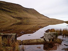
The highest point (county top) is the minor summit of Fan Foel, height 781 metres (2,562 ft), which is a subsidiary top of the higher mountain of Fan Brycheiniog, height 802.5 metres (2,633 ft) (the higher summit, as its name suggests, is actually across the border in Brecknockshire/Powys).
[14] The principal towns in the county are Ammanford, Burry Port, Carmarthen, Kidwelly, Llanelli, Llandeilo, Newcastle Emlyn, Llandovery, St Clears, and Whitland.
[16] The lowest bridge over the river is at Carmarthen, and the Towi Estuary cuts the southwesterly part of the county, including Llansteffan and Laugharne, off from the more urban southeastern region.
On improved pastures, dairying is important and in the past, the presence of the railway enabled milk to be transported to the urban areas of England.
[14] The creamery at Whitland is now closed but milk processing still takes place at Newcastle Emlyn where mozzarella cheese is made.
[18] On upland pastures and marginal land, livestock rearing of cattle and sheep is the main agricultural activity.
[15] In the north of the county, in and around the Teifi Valley, there was a thriving woollen industry in the nineteenth and early twentieth centuries.
The gross value added economic indicator showed a figure of £14,763 per head in these regions, as compared with a GVA of £22,986 for Cardiff and the Vale of Glamorgan.
[21] In 2015, in an attempt to boost the local economy, Carmarthenshire County Council produced a fifteen-year plan that highlighted six projects which it hoped would create five thousand new jobs.
The sectors involved would be in the "creative industries, tourism, agri-food, advanced manufacturing, energy and environment, and financial and professional services".
[36] The 2011 census showed a further decline, with 43.9 per cent speaking Welsh, making it a minority language in the county for the first time.
[39] With its strategic location and history, the county is rich in archaeological remains such as forts, earthworks and standing stones.
Dylan Thomas Boathouse where the author wrote many of his works can be visited, as can the Roman-worked Dolaucothi Gold Mines.
[42] Activities available in the county include rambling, cycling, fishing, kayaking, canoeing, sailing, horse riding, caving, abseiling and coasteering.
It was opened in 1989 on a former airfield, is popular for testing and has hosted many events including the British Touring Car Championship twice.
The line continues westwards with several branches which serve Pembroke Dock, Milford Haven and Fishguard Harbour (for the ferry to Rosslare Europort and connecting trains to Dublin Connolly).
The A40 links Carmarthen to Llandeilo, Llandovery and Brecon to the east, and with St Clears, Whitland and Haverfordwest to the west.
[55] Carmarthenshire has rich, fertile farmland and a productive coast with estuaries providing a range of foods that motivate many home cooks and chefs.