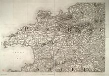
Pembrokeshire
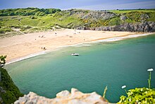
It is a varied landscape which includes high sea cliffs, wide sandy beaches, the large natural harbour of Milford Haven, and several offshore islands which are home to seabird colonies.
During the Middle Ages several castles were built by the Normans, such as Pembroke and Cilgerran, and St David's Cathedral became an important pilgrimage site.
During the Industrial Revolution the county remained relatively rural, with the exception of Milford Haven, which was developed as a port and Royal Navy dockyard.
More recent rock formations were eroded when sea levels rose 80 million years ago, at the end of the Cretaceous Period.
The park contains the Pembrokeshire Coast Path, a near-continuous 186-mile (299 km) long-distance trail from Amroth, by the Carmarthenshire border in the southeast, to St Dogmaels just down the River Teifi estuary from Cardigan, Ceredigion, in the north.
[26] In the north of the county are the Preseli Mountains, a wide stretch of high moorland supporting sheep farming and some forestry, with many prehistoric sites and the probable source of the bluestones used in the construction of the inner circle of Stonehenge in England.
[28][29] The county has a number of seasonal seabird breeding sites, including for razorbill, guillemot, puffin and Manx shearwater,[30] and rare endemic species such as the red-billed chough;[31]: 133–135 Grassholm has a large gannet colony.
"[40] The Wildlife Trust of South and West Wales is in the process of restoring a lost temperate rainforest, also known as a Celtic forest, in Trellwyn Fach, near the town of Fishguard.
[45]: 52, 17, 30, 34 The Déisi merged with the local Welsh, with the regional name underlying Demetae evolving into Dyfed, which existed as an independent petty kingdom from the 5th century.
Between the Roman and Norman periods, the region was subjected to raids from Vikings, who established settlements and trading posts at Haverfordwest, Fishguard, Caldey Island and elsewhere.
Rhys ap Gruffydd, the son of Owain Gwynedd's daughter Gwenllian, re-established Welsh control over much of the region and threatened to retake all of Pembrokeshire, but died in 1197.
[45]: 106, 112, 114 In 1284 the Statute of Rhuddlan was enacted to introduce the English common law system to Wales,[60] heralding 100 years of peace, but had little effect on those areas already established under the Marcher Lords, such as Cemais in the north of the county.
[63]: 337–379 The Laws in Wales Act 1535 effectively abolished the powers of the Marcher Lords and divided the county into seven hundreds, roughly corresponding to the seven pre-Norman cantrefi of Dyfed.
[55]: 310 During the First English Civil War (1642–1646) the county gave strong support to the Roundheads (Parliamentarians), in contrast to the rest of Wales, which was staunchly Royalist.
In spite of this, an incident in Pembrokeshire triggered the opening shots of the Second English Civil War when local units of the New Model Army mutinied.
[69] In 1791 a petition was presented to the House of Commons concerning the poor state of many of the county's roads, pointing out that repairs could not be made compulsory by the law as it stood.
[87] Under the Local Government Act 1888, an elected county council was set up to take over the functions of the Pembrokeshire Quarter Sessions.
[96][97] In 1996, under the Local Government (Wales) Act 1994, the county of Dyfed was broken up into its constituent parts, and Pembrokeshire has been a unitary authority since then.
The A487 is the other major route, running northwest from Haverfordwest to St Davids, then northeast following the coast, through Fishguard and Newport, to the boundary with Ceredigion at Cardigan.
Since the 1950s, petrochemical and liquid natural gas industries have developed along the Milford Haven Waterway and the county has attracted other major ventures.
In 2016, Stephen Crabb, then Welsh Secretary, commented in a government press release: "...with a buoyant local economy, Pembrokeshire is punching above its weight across the UK.
[127] Pembrokeshire has good soil and benefits from the Gulf Stream, which provides a mild climate and a longer growing season than other parts of Wales.
[128]: 142 Pembrokeshire's mild climate means that crops such as its new potatoes (which have protected geographical status under European law)[129] often arrive in British shops earlier in the year than produce from other parts of the UK.
[130] The county lends its name to the Pembroke Welsh Corgi, a herding dog whose lineage can be traced back to the 12th century,[131]: 6 but which in 2015 was designated as a "vulnerable" breed.
[140] There are two oil refineries, two liquified natural gas (LNG) terminals and the 2,000 MW gas-fired Pembroke Power Station (opened in 2012) at Milford Haven.
[149] In 2011 the first solar energy farm in Wales was installed at Rhosygilwen, Rhoshill with 10,000 panels in a field of 6 acres (2.4 ha), generating 1 MW.
[165][166] Pembrokeshire has more than 1,600 listed buildings, ranging from mud huts to castles, and including bridges and other ancient and modern structures, under the auspices of Cadw and the County Council.
[202] Ras Beca, a mixed road, fell and cross country race attracting UK-wide competitors, has been held in the Preselis annually since 1977.
[220] The pirate Bartholomew Roberts (Black Bart) (Welsh: Barti Ddu) was born in Casnewydd Bach, between Fishguard and Haverfordwest in 1682.
A February 2020 report by schools' inspection body Estyn, however, considered the local authority's performance in education provision "a significant concern".