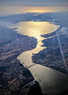
Carquinez Strait
The strait formed in prehistoric times, near the close of one of the past ice ages, when the Central Valley was a vast inland lake.
[3] Andrei Sarna-Wojcicki, a geologist emeritus of the US Geological Survey (USGS), estimates that the Carquinez Strait was likely formed about 640,000 to 700,000 years ago, while much of modern California was emerging from an ice age.
At some point, the coastal barrier collapsed between today's cities of Crockett and Benicia, releasing lake water in a cataclysmic flood.
The cities of Benicia and Vallejo lie on the north side of the strait, while Martinez, Port Costa, and Crockett sit on the southern coast.
The strait is too small to allow the passage of huge amounts of floodwaters created during years with heavy rainfall or snowmelt events.
[citation needed] By the early 20th century, farmers in the Sacramento-San Joaquin Delta, who depended on irrigating their fields with fresh water from the two rivers noticed an increase in salinity farther inland than before.
It became obvious that fresh water was being pumped out of the Delta faster than it could be replenished by rain and snow during the wet season.
A political consensus formed that damming the Carquinez Strait should solve the seawater intrusion problem.
However, it took four years to complete the decision-making process that officially named Army Point as the future dam site.
[6][b] On January 24, 1930, with the Great Depression taking hold, President Herbert Hoover cancelled the Carquinez Strait project, saying that it was too costly.