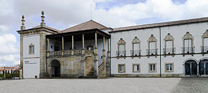
Castelo Branco, Portugal
The municipality, with 52,272 inhabitants,[2] is made up of 19 freguesias (civil parishes) spread through 1,438.19 km2 (555.29 sq mi), making it the 3rd largest in Portugal by total land area.
[3] The municipality is bounded in the north by Fundão, in the east by Idanha-a-Nova, in the south by Spain, in the southwest by Vila Velha de Ródão, and in the west by Proença-a-Nova and Oleiros.
Castelo Branco gets its name from the prior existence of a Luso-Roman castrum or fortified settlement called Castra Leuca, on the summit of the hill of Colina da Cardosa.
There is, nevertheless, a document, from this date, mentioning the donation to the Templars of a piece of land called Vila Franca da Cardosa, by a noble Fernandes Sanches.
After 1496, Castelo Branco became an important center for marranos, Jews who had converted to Christianity publicly, but still practiced Judaism secretly.
It is one of the most beautiful Baroque gardens in Portugal and contains statues of allegories, kings and zodiacal signs, arranged around ponds, terraces and staircases.
It runs via Abrantes, Rodão, Castelo Branco and Fundão with services currently terminating at Covilhã some 30 kilometres (19 miles) short of Guarda.
For lengthy stretches the single track clings to the NW flanks of the reservoirs providing exhilarating forested views as you speed along the waterside.
After passing through some deep gorges into Rodao station the line then heads north away from the river and on to Castelo Branco and finally Covilhã.
This scenic stretch of mountainous rural line provides the strategic last leg of the Beira Baixa Railway linking it to Guarda via Belmonte.