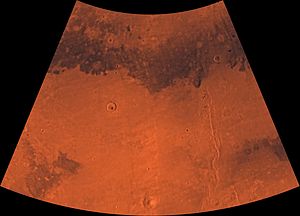
Cebrenia quadrangle
[4] The quadrangle's prominent features are the large craters Mie and Stokes, a volcano, Hecates Tholus, and a group of mountains, Phlegra Montes.
This area is a flat, smooth plain for the most part, so the relatively large craters Mie and Stokes really stand out.
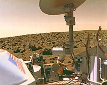
There would be a hard crust on the top of the soil similar to a deposit, called caliche which is common in the U.S. Southwest.
[8] Scientists, in a September 2009 article in the journal Science, have asserted that if Viking 2 only dug four inches deeper, it would have reached a layer of almost pure ice.
The tested soil contained abundant silicon and iron, along with significant amounts of magnesium, aluminum, sulfur, calcium, and titanium.
Some chemicals in the soil contained sulfur and chlorine that were like typical compounds remaining after the evaporation of sea water.
[14] Using results from the chemical measurements, mineral models suggest that the soil could be a mixture of about 90% iron-rich clay, about 10% magnesium sulfate (kieserite?
The study's authors found that perchlorate will destroy organics when heated and will produce chloromethane and dichloromethane, the identical chlorine compounds discovered by both Viking landers when they performed the same tests on Mars.
Because perchlorate would have broken down any Martian organics, the question of whether or not Viking found life is still wide open.
The ice was confirmed with the Compact Imaging Spectrometer (CRISM)] on board the Mars Reconnaissance Orbiter (MRO).
[9][10][11] This discovery proves that future colonists on Mars will be able to obtain water from a wide variety of locations.
The ice can be dug up, melted, then taken apart to provide fresh oxygen and hydrogen for rocket fuel.
Since the collision that produces a crater is like a powerful explosion, rocks from deep underground are tossed onto the surface.
Recent research leads scientists to believe that Hecates Tholus erupted explosively about 350 million years ago.
When hot subsurface molten rock comes close to this ice, large amounts of liquid water and mud may be formed.
Hrad Vallis in the Cebrenia quadrangle is close to Elysium Mons, a large volcano, which may have supplied water to create the channel.
It does not have associated outflow channels, and it does not display a great elevation difference between it and the surrounding land area, as most of the other chaos regions.
Research by Pedersen and Head, published in 2010, suggests that Galaxias Chaos is the site of a volcanic flow that buried an ice-rich layer, called the Vastitas Borealis Formation (VBF).
It is generally believed that the VBF is a residue from water-rich materials deposited by large floods.
In the thin atmosphere of Mars, this layer would have slowly disappeared by sublimation (changing from a solid directly to a gas).
There are volcanoes, namely Elysium Montes and Hecates Tholus, nearby which most likely are surrounded by dikes, which would have heated the ground.
[31] Glaciers, loosely defined as patches of currently or recently flowing ice, are thought to be present across large but restricted areas of the modern Martian surface, and are inferred to have been more widely distributed at times in the past.
A variety of surface textures seen in imagery of the midlatitudes and polar regions are also thought to be linked to sublimation of glacial ice.
[48][49][50][51] Indeed, a study published in June 2017, calculated that the volume of water needed to carve all the channels on Mars was even larger than the proposed ocean that the planet may have had.
The wind speed next to the boulder may be higher—just as air moving over an airplane's wing goes faster on the upper, curved part.
The water returns to the ground at lower latitudes as deposits of frost, snow, and dust.
The atmosphere of Mars contains a great deal of fine dust particles.