List of ancient Celtic peoples and tribes

They were most of the population in Gallia, today's France, Switzerland, possibly Belgica – far Northern France, Belgium and far Southern Netherlands, large parts of Hispania, i.e. Iberian Peninsula – Spain and Portugal, in the northern, central and western regions; southern Central Europe – upper Danube basin and neighbouring regions, large parts of the middle Danube basin and the inland region of Central Asia Minor or Anatolia.

They lived in these many regions forming a large arc stretching across from Iberia in the west to the Balkans and Anatolia in the east.

Classical Antiquity authors did not describe the peoples and tribes of the British Islands as “Celts” or “Galli” but by the name “Britons”.

[1] Source:[2] They lived in Southern Central Europe (in the Upper Danube basin and neighbouring regions) which is hypothesized as the original area of the Celts (Proto-Celts), corresponding to the Hallstatt Culture.

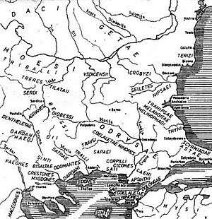
Later they expanded towards the Middle Danube valley and to parts of the Balkans and towards inland central Asia Minor or Anatolia (Galatians).

Hercynian Forest (Hercynia Silva), north of the Danube and east of the Rhine was in their lands.

These people, called Galatians, a generic name for “Celts”, were eventually Hellenized,[22][23] but retained many of their own traditions.

Galli (Gauls), for the Romans, was a name synonym of “Celts” (as Julius Caesar states in De Bello Gallico[25]) which means that not all peoples and tribes called “Galli” were necessarily Gauls in a narrower regional sense.

They seem to have been an older group of Celts that lived in Cisalpine Gaul before the Gaulish Celtic migration.

Eastern Iberian meseta (Spain), mountains of the headwaters of the rivers Douro, Tagus, Guadiana (Anas), Júcar, Jalón, Jiloca and Turia, (tribal confederation).

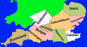
There were three or four distinct Celtic populations in these islands, in Britannia inhabited the Britons, the Caledonians or Picts, the Belgae (not surely known if they were a Celtic people or a distinct but closely related one); in Hibernia inhabited the Hibernians or Goidels or Gaels.

Classical Antiquity authors did not call the British islands peoples and tribes as Celts or Galli but by the name Britons (in Britannia).

According to Ptolemy's Geography (2nd century AD) (in brackets the names are in Greek as on the map): Para-Celtic has the meaning that these peoples had common ancestors with the Celts but were not Celts themselves (although they were later Celticized and belong to a Celtic culture sphere of influence), they were not direct descendants from the Proto-Celts.

Because of the strong Celtic influences on their language and culture, they were known already in antiquity as Celto-Ligurians (in Greek Κελτολίγυες, Keltolígues).

Today's Western Andalusia (Hispania Baetica), Baetis (Guadalquivir) river valley and basin, Marianus Mons (Sierra Morena), some consider them Celtic,[43] may have been Pre-Celtic Indo-European people as the Lusitani and Vettones.

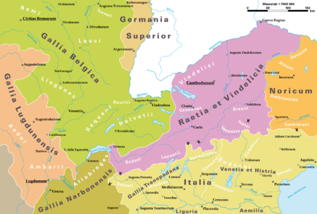
They lived in the Central Alps, eastern parts of present-day Switzerland, the Tyrol in Austria, and the Alpine regions of northern Italy.

Map1: Diachronic distribution of Celtic peoples (ancient and modern):
core Hallstatt territory, by the 6th century BC
maximal Celtic expansion, by 275 BC
Two land areas in Iberian Peninsula where Celtic presence is uncertain or disputed by some: Lusitanian and Vettonian land (Para-Celtic?), Caristii and Varduli land (Vasconic, Celtic or Para-Celtic?), in today's Basque Country .
the six Celtic nations which retained significant numbers of Celtic speakers into the Early Modern period
areas where Celtic languages remain widely spoken today
Map 3: Roman district (probably not yet a full province by then) of Raetia et Vindelicia , as it stood in AD 14. Celts dwelt in most areas of the shown land on the map except for the Rhaetians .
Map 4: Ancient tribes in the middle Danube river basin around 1st C. BCE
Map 5: Central and northern Illyrian tribes and neighbouring Celtic tribes (most in magenta) to the North and Northwest during the Roman period.
Map 6: Tribes in Thrace before the Roman period. Some of the tribes shown, such as the Serdi were Celts .
Map 7: Classical regions of Asia Minor / Anatolia . Galatia were Galatians dwelt is in the centre.
Map 8: Gaul (58 BC) with important tribes, towns, rivers, etc. and early Roman provinces .
Map 9: Gaul ( Gallia ) on the eve of Roman conquest ( Celtica , which included Armorica , Belgica and Aquitania Propria were conquered while Narbonensis was conquered earlier, already ruled by the Roman Republic ). The map shows the ethnic and linguistic kinship of the tribes by different colours (the map is in French).
Map 10: Roman Gaul at the end of the 1st century B.C. (Droysens Allgemeiner historischer Handatlas, 1886), with important tribes, towns, rivers, etc. and Roman provinces .
Map 11: Peoples of northern Italy during the 4th to 3rd centuries BC (Celtic tribes are shown in blue) (map names are in French)
Map 12: Roman Hispania , at the end of the 1st century B.C. (Droysens Allgemeiner historischer Handatlas, 1886), with important tribes, towns, rivers, etc. and Roman provinces .
Map 13: Celts in the Iberian Peninsula , despite the name, a large part of the peninsula was celtic.
Map 14: Territory of the Celtiberi , mixed Celtic and Iberian tribes or Celtic tribes influenced by Iberians, with the possible location of the tribes. The names of the tribes are in Castillian or Spanish (whose plural grammatical number descends from the Latin plural accusative declension).
Map 15: Southern Britain about the year 150 AD
Map 16: Wales about the year 40 AD
Map 17: Northern Britain about the year 150 AD
Map 18: The population groups (tribes and tribal confederations) of Ireland ( Iouerníā / Hibernia ) mentioned in Ptolemy 's Geographia in a modern interpretation. Tribes' names on the map are in Greek (although some are in a phonetic transliteration and not in Greek spelling).
Map 19: According to Strabo , the Belgian tribes (in orange) (the map is in French).
Map 20: Belgae ( Belgae Proper tribe, the Atrebates and possibly the Regni or Regnenses and Catuvellauni ) and neighbouring tribes ( Britons Proper) in Britannia ( Britain ).
Map 21: Peoples of northern Italy during the 4th to 3rd centuries BC. Ligurians are shown in the west coastal region (north coast of the Ligurian Sea , part of the Mediterranean Sea ) to the south of the Celts (shown in blue) and to the northwest of the Etruscans, in the left side of the map. (map names are in French)
Map 22: Celts in the Iberian Peninsula , area dwelt by the Lusitani and Vettones is shown in lighter green colour.
Map 23: Hispania Baetica Roman province, Turdetani were the inhabitants in large parts of this province before Roman conquest along the Baetis or Rherkes river plain.
Map 22: Roman district (probably not yet a full province by then) of Raetia et Vindelicia , as it stood in AD 14, with some Rhaeti tribal names ( Breuni , Camunni , Isarci , Vennones or Vennonetes , Venostes ).