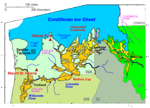
Channeled Scablands
[3][4][5] These floods were periodically unleashed whenever a large glacial lake broke through its ice dam and swept across eastern Washington and down the Columbia River Plateau during the Pleistocene epoch.
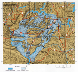
[6] Geologist J Harlen Bretz defined "scablands" in a series of papers written in the 1920s as lowlands diversified by a multiplicity of irregular channels and rock basins eroded into basalt.
Bretz further stated, "The channels run uphill and downhill, they unite and they divide, they head on the back-slopes and cut through the summit; they could not be more erratically and impossibly designed.
Distinct geomorphological features include coulees, dry falls, streamlined hills and islands of remnant loess, gravel fans and bars, and giant current ripples.
[7] The term scabland refers to an area that has experienced fluvial erosion resulting in the loss of loess and other soils, leaving the land barren.
The Channeled Scablands have a rectangular cross section, with flat plateaus and steep canyon sides, and are spread over immense areas of eastern Washington.
[10] A series of floods occurring over the period of 18,000 to 13,000 years ago swept over the landscape when the ice dam broke.
Based on the presence of multiple interglacial calcretes interbedded with glaciofluvial flood deposits, magnetostratigraphy, optically stimulated luminescence dating, and unconformity truncated clastic dikes, it has been estimated that the oldest of these megafloods flowed through the Channel Scablands sometime before 1.5 million years ago.