Charlottetown
The first European settlers in the area were French; personnel from Fortress Louisbourg founded a settlement in 1720 named Port La Joye on the southwestern part of the harbour opposite the present-day city.
British forces built Fort Amherst near the site of the abandoned Port La Joye settlement to protect the entrance to the harbour.
During the attack, the colonial seal was stolen and several prisoners, including Phillips Callbeck and Thomas Wright, were taken to Cambridge, Massachusetts and later released.
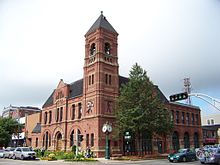
The completion of this structure with Isaac Smith as builder/architect was an important milestone in the history of the capital and it is still in use today as the provincial legislature as well as a National Historic Site, and is currently the second-oldest legislative seat in Canada.
Although many of the meetings and negotiations which would lead to Canadian Confederation were held in Province House, various social events spilled over into the surrounding community.
Aside from being the seat of colonial government, the community came to be noted during the early nineteenth century for shipbuilding and its lumber industry as well as being a fishing port.
Charlottetown's shipyards were used extensively during World War II, being used for refits and upgrades to numerous Royal Canadian Navy warships.
The PEI Comprehensive Development Plan in the late 1960s greatly contributed to the expansion of the provincial government in Charlottetown for the next decade.
A waterfront hotel and convention centre was completed in 1982 and helped to encourage diversification and renewal in the area, leading to several residential complexes and downtown shopping facilities.
In the late 1990s and 2000s, the retail landscape changed with the opening of big box stores on the site of former traditional shopping centres and in new developments in the northern suburbs, particularly the neighbourhood of West Royalty, which is a key road junction.
On May 31, 2021, the Charlottetown City Council voted to remove a statue of John A. MacDonald, the first Prime Minister of Canada, following a year of vandalism in the wake of the George Floyd Protests.
The catalyst for the removal came following the discovery of a mass grave at the Kamloops Indian Residential School in British Columbia.
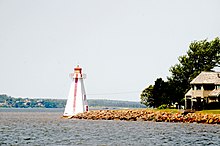
Charlottetown is situated on its namesake harbour, which is formed by the confluence of three rivers in the central part of the island's south shore.
Charlottetown has a humid continental climate (Köppen Dfb) moderated partially by Prince Edward Island's location in the Gulf of Saint Lawrence.
[15] Downtown Charlottetown includes the city's historic five hundred lots, as surveyed by Captain Samuel Holland, as well as the waterfront facing the harbour and the Hillsborough River.
The Agriculture Canada research station farm is the last remnant of the Queens Royalty common pasture lands and creates a large greenspace in the centre of the city, north of downtown.
The development of the township of Queens Royalty, with its 5-hectare (12-acre) estates surveyed during the 18th and 19th centuries along a north–south axis forced early road networks into a grid.
Commercial development, aside from the central business district, is concentrated along several road corridors: The downtown core is augmented by several feeder streets: Charlottetown comprises the following neighbourhoods which were one-time independent municipalities: The original municipal boundary between Charlottetown and the common area of the township of Queens Royalty was the northern edge of the original five hundred lots along present-day Euston Street.
This boundary was extended north to Allen Street and Kirkwood Drive during the early twentieth century, taking in part of the rural community of Brighton west of the downtown.
Municipal amalgamation in 1996 saw the outlying independent municipalities of Parkdale (town), Sherwood, East Royalty, West Royalty and Winsloe (villages) merged into a larger city of Charlottetown at the same time as rural communities east and west of the city were amalgamated to form the towns of Stratford and Cornwall respectively.
A green belt is in place around the northern fringe of the municipal boundary, although it is poorly enforced by the provincial government, leading to suburban sprawl.
The city's streetscape with a centrally planned downtown core containing many Victorian-era houses and buildings is an attraction, as well as the waterfront redevelopment project in recent decades which has seen walking trails and parks developed on former industrial lands.
A new cruise ship terminal was opened by the port authority in September 2007 which, proponents hope, will make the city a more attractive destination for the growing number of vessels operating in the Gulf of St. Lawrence.
There are 11 National Historic Sites of Canada located in Charlottetown, including Province House and the Confederation Centre of the Arts.
Amateur varsity team sports are prevalent for males and females in the city's two senior high schools, Colonel Gray and Charlottetown Rural, as well as the University of Prince Edward Island's varsity teams (the UPEI Panthers) through the institution's affiliation with Canadian Interuniversity Sport.
The 2021 census reported that immigrants (individuals born outside Canada) comprise 5,245 persons or 13.9% of the total population of Charlottetown.
The provincial, federal, and municipal levels of government are significant employers in the central part of Queens County, as are the health care and secondary and post-secondary education sectors.
The city's municipal government is structured around a council comprising a mayor and ten councillors elected using the ward system.
Route 1, the Trans-Canada Highway, partially bisects the northern suburbs, linking with Riverside Drive, the Hillsborough River Bridge and the North River Causeway/Bridge on a limited-access arterial highway linking the city with the Confederation Bridge in the west and the Northumberland Ferries terminal in the east.
[citation needed] The absence of public transit for many decades in Charlottetown resulted in a dependence on personal use of automobiles, with municipal governments constructing three large above-ground parking garages in the city's historic district to house vehicles of downtown workers.