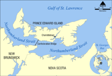
Northumberland Strait
The western boundary of the strait is delineated by a line running between North Cape, Prince Edward Island and Point Escuminac, New Brunswick while the eastern boundary is delineated by a line running between East Point, Prince Edward Island and Inverness, Nova Scotia.
[1][2] The strait's shallow depths lend to warm water temperatures in summer months, with some areas reaching 25°C, or 77°F.
There was a year-round ferry service that operated in the central/western part of the strait across Abegweit Passage between Port Borden, Prince Edward Island and Cape Tormentine, New Brunswick.
This interconnection consisted of two 23 km (14 mi) 138 kilovolt oil-filled submarine transmission cables installed 1975-78 under the Northumberland Strait at the western end of the Abegweit Passage between Murray Corner, New Brunswick and Fernwood, Prince Edward Island.
Bell Aliant has two fibre optic telecommunications cables spanning Northumberland Strait to serve Prince Edward Island.
Eastlink has a fibre optic telecommunications cable connecting Gaspereau, Prince Edward Island with Port Hood, Nova Scotia.
Swim-related details about crossings, tides, currents, marine life, and navigation can be found at OpenWaterPedia's Northumberland Strait page.
[5] There have been two documented single-day double crossings of Abegweit Passage (approximately 27 kilometres (15 nmi)) with assistance to date: The first and to date only, documented single crossing with assistance across the eastern end of the strait (approximately 24.5 kilometres (13.2 nmi) was made by Jill Leon of Charlottetown, PEI on July 31, 2013, when she swam from Caribou, NS to Wood Islands, PEI in 9 hours, 48 minutes.