Chickahominy River
During the American Civil War (1861–65), the upper reaches of the river became a major obstacle to Union General George B. McClellan's Peninsula Campaign, a failed attempt in 1862 to capture the Confederate capital of Richmond.
Docile, narrow, and relatively easily crossed during dry weather, after periods of rain, the river expands across a flood plain with swamps as much as a mile across.
For its first 15 miles (24 km), the Chickahominy flows over igneous and metamorphic bedrock of the Piedmont, but soon becomes a Coastal Plain stream near Mechanicsville.
4 miles (6.4 km) southeast of Providence Forge, the Chickahominy River becomes an estuary and makes a turn towards to the south.
As sea level rose after the last glacial interval (during the last 20,000 years), the Chickahominy has also risen, causing old flood plains and valleys to be backfilled as marshes.
In 1607, Captain John Smith, one of the Jamestown settlers, traveled with others up the Chickahominy in the hope that it would prove to be a passage to the Pacific Ocean.
In the 19th century, the Chickahominy River was bordered in many places by swampy forests, which during heavy rains and spring thaw were so covered with water as to be almost impassable.
The Confederates retreated northwest and crossed the Chickahominy near the point where New Kent, Henrico, and Hanover counties border each other, in modern times known as Bottoms Bridge.
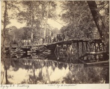
At first the Union troops were driven back and almost beaten, but meanwhile the soldiers on the other side of the Chickahominy had succeeded in building a bridge.
Instead of trying to prevent this, General McClellan resolved to change his base to Harrison's Landing or City Point on the James River, about 30 miles (48 km) east of Richmond.
The Confederates had already attacked the Union Army at Mechanicsville on the east side of the river, but after the bloody battle they were driven back (June 26).
They might easily have taken most of the city, for General Lee and most of his army were still on the east side of the Chickahominy, and farther away from Richmond than McClellan was.
On the next day they made another fierce attack at Frayser's Farm, where a bloody battle was fought without much advantage being gained on either side.
After one of the bloodiest battles of the war, the Unionists were driven back, leaving the ground covered with dead and wounded.
Located just west of the previous structure, it rises to a height of 52 feet (16 m) and includes a separate pathway for the Virginia Capital Trail.