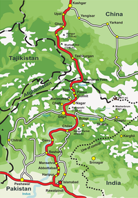
Chilas
To the north, Chilas connects to the cities of Tashkurgan and Kashgar in Xinjiang, China, via Gilgit, Aliabad, Sust, and the Khunjerab Pass.
The beautiful Fairy Meadows National Park and Nanga Parbat, the ninth highest peak in the world, are also located in Chilas.
Though administratively lumped with Gilgit, Chilas and its neighbours are temperamentally more like Indus Kohistani people, probably due to a similarly hostile environment and the same Sunni Muslim orthodoxy.
[6] Chilas Fort was first garrisoned to protect British supply lines over the Babusar Pass, and beefed up after local tribes nearly overran it in 1893.
The Kharoshthi term "Kaboa" (or Kamboa) appears in a short commemorative Kharosthi inscription found from Chilas as reported by the Archaeological Department of Pakistan.
The inscription has been transcribed, translated and interpreted by Ahmad Hasan Dani, a Pakistani archaeologist, historian, and linguist, who was among the foremost authorities on South Asian archaeology and history.