Karakoram Highway
The highway connects the Pakistani provinces of Punjab and Khyber Pakhtunkhwa plus Gilgit-Baltistan with China's Xinjiang Uyghur Autonomous Region.
In 1966, China, citing the fact that Mintaka would be more susceptible to air strikes, recommended the steeper Khunjerab Pass instead.
On the Pakistani side, the road was constructed by FWO (Frontier Works Organisation), employing the Pakistan Army Corps of Engineers.
The book History of Karakoram Highway was written by Brigadier (Retired) Muhammad Mumtaz Khalid in two volumes.
to link the Karakoram Highway to the southern port of Gwadar in Balochistan through the Chinese-aided Gwadar-Dalbandin railway, which extends to Rawalpindi.
[13] In July 2012, Pakistan began constructing a revised route around the lake at a higher elevation with five new tunnels, with a total length of 7.12 km and two new bridges.
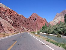
The western end of the Himalayas, marked by the ninth highest peak in the world, Nanga Parbat, can be seen from the highway.
As part of the $46 billion China Pakistan Economic Corridor, reconstruction and upgrade works on the Pakistani portion of the Karakoram Highway (KKH) are underway.
The 24 km (15 mi) long series of bridges and tunnels was inaugurated on 15 September 2015 at a cost of $275 million[clarification needed] and was hailed as a major accomplishment.
The Chinese section of the Karakoram Highway follows the north-south Sarykol ("Yellow Lake") valley just west of the Tarim Basin.
Having climbed up to the valley, the road turns south past Kongur, Karakul Lake, and Muztagh Ata on the east.
Below Muztagh Ata, a new road goes west over the Kulma Pass to join the Pamir Highway in Gorno-Badakhshan, Tajikistan.
In recent years the highway has sought to become a 'niche' adventure tourism destination although Pakistan attracts few international tourists compared to domestic ones.
But in recent years, owing to the improved security situation in the country, the number of foreign tourists[18] coming to Pakistan has more than tripled since 2013, standing at 1.75 million in 2016.
These include: There are more than 50,000 pieces of rock art and petroglyphs all along the highway that are concentrated at ten major sites between Hunza and Shatial.
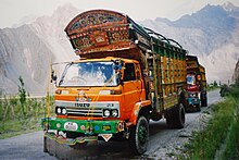
There are several transport companies in Pakistan that offer bus service between major towns of the highway and from Rawalpindi and Lahore.
On 1 June 2006, daily bus service began between Gilgit, Gilgit–Baltistan, and Kashgar, Xinjiang, through the Sust and Tashkorgan border area.
The proposed Xinjiang-GB-Azad Kashmir road would be linked to Yarkant County in Xinjiang, and enter Gilgit-Baltistan through Mustagh Pass, 126 km west of Ladakh, crossing the major supply artery from the Karakoram Highway near Skardu city.
[27] A road tunnel is proposed to be constructed through the mountains to connect Astore to the Neelum Valley in the Azad Kashmir region.