Chinnar Wildlife Sanctuary
It forms an integral part of the 1,187 km2 (458 sq mi) block of protected forests straddling the Kerala-Tamil Nadu border in the Anaimalai Hills.
[4] CWS is located between latitude 10º15' - 10º21' N and longitude 77º5' - 77º16' E. [5] The Munnar – Udumalpet road SH 17 passes through the sanctuary for 16 km and divides it into nearly equal portions.
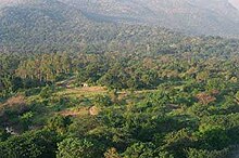
Average annual rainfall is only 500 mm, spread over about 48 days, because it is in the rain shadow region of the southern Western Ghats.
[citation needed] The Chinnar and Pambar rivers are the major perennial water resources in the sanctuary.
The Chinnar originates near Kumarikal Malai, follows the interstate boundary along the northwest edge of the sanctuary for 18 km and becomes the Amaravati River in Tamil Nadu.
[citation needed] There are 11 tribal settlements inside the Chinnar WLS, each is well demarcated by temporary stone walls.