Mountaineering on Mount Kenya
Starting clockwise from the north these are the: Meru, Chogoria, Kamweti, Naro Moru, Burguret, Sirimon and Timau Routes.
[4][6] This route leads from Katheri, south of Meru, to Lake Rotundu following the Kathita Munyi river.
[2] There is much wildlife in the forest, with safari ant columns crossing the track, monkeys in the trees, and the potential for seeing elephant, buffalo and leopard.
The route drops down into the Northern Naro Moru Valley to Mackinder's Camp on the Peak Circuit Path.
[6] It starts in Gathiuru, and mainly follows the North Burguret River, then continues up to Hut Tarn on the Peak Circuit Path.
They came together and formed the Gathiuru Community Forest Association which was aimed at conserving the two great natural resources as they make a living.
This is a lodge situated opposite the Nanyuki airstrip and has entered into a partnership with the association to help market the route for the locals so that the community benefits.
This route starts 15 km (9.3 mi) east around the Mount Kenya Ring Road from Nanyuki.
On the northern side of the mountain there is no bamboo zone, so the forest gradually turns into moorland covered with giant heather.
[4] It starts very close to the Sirimon Route, at Timau Village, and skirts around the edge of the forest for a considerable distance.
From the trackhead it is possible to reach Halls Tarns in a few hours, then follow the Chogoria Route to the Peak Circuit Path.
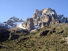
[5] This is a path around the main peaks, with a distance of about 10 kilometres (6 mi) and height gain and loss of over 2,000 metres (6,600 ft).
[4] The huts range from very basic (Liki North) with little more than a roof, to luxurious with log fires and running water (Meru Mt Kenya Lodge).
The communal areas of the huts can be used by campers wishing to retreat from the weather or to store food away from the hyaena and hyraxes.
The first European to report seeing Mount Kenya was Dr Johann Ludwig Krapf, a German missionary, from Kitui in 1849,[21] a town 160 kilometres (100 mi)[22] away from the mountain.
[25] Eventually, in 1883, Joseph Thomson passed close by the west side of the mountain and confirmed Krapf's claim.
He diverted his expedition and reached 1,737 metres (5,700 ft) up the slopes of the mountain but had to retreat because of trouble with local people.
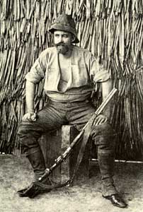
[26] However, the first European exploration high onto the mountain was achieved in 1887 by Count Sámuel Teleki and Ludwig von Höhnel.
This expedition was travelling from the coast to Lake Baringo in the Rift Valley, and was led by Dr John W Gregory, a British geologist.
[2] George Kolb, a German physician, made expeditions in 1894 and 1896[2] and was the first to reach the moorlands on the east side of the mountain.
[2][29] On 28 July 1899,[29] Sir Halford John Mackinder set out from the site of Nairobi on an expedition to Mt Kenya.
When they reached the base camp on 18 August,[29] they could not find any food, had two of their party killed by the local people, and eventually had to send Saunders to Naivasha to get help from Captain Gorges, the Government Officer there.
On 5 September, Hausberg, Ollier and Brocherel made a circuit of the main peaks looking for an easier route to the summit.
On 11 September Ollier and Brocherel made an ascent of the Darwin Glacier, but were forced to retreat due to a blizzard.
A Church of Scotland mission was set up in Chogoria, and several Scottish missionaries ascended to the peaks, including Rev Dr. J. W. Arthur, G. Dennis and A. R. Barlow.
They ascended by the West Ridge of Batian, traversed the Gate of Mists to Nelion, and descended the Normal Route.
In February Miss Carol W. Carroll and Ayub Mtu Muthara became the first woman and African respectively to ascend Nelion, in an expedition with Noel Symington, author of The Night Climbers of Cambridge, and on 5 March Miss Una Cameron became the first woman to ascend Batian.
[31] In the early 1970s the Mount Kenya National Park Mountain Rescue Team was formed, and by the end of the 1970s all major routes on the peaks had been climbed.