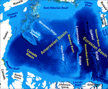
Chukchi Plateau
The ridge is normally covered by ice year-round, and reaches an approximate bathymetric prominence of 3,400 m with its highest point at 246 m below sea level.
[1] As a subsea ridge extending from the continental shelf of the United States north of Alaska, the Chukchi Plateau is an important feature in maritime law of the Arctic Ocean and has been the subject of significant geographic research.
The difficulties associated with collecting marine geologic and geophysical data in this remote region has added to the debate on the tectonic history of the Arctic Ocean and the formation of its bathymetric features.
Although there is no consensus as to the pre-rift location of the Chukchi Borderland, its tectonic migration could be attributed to an inferred spreading center indicated by a linear gravity low in the Canada Basin [citation needed].
The second yields the Gardiner Line, which refers to the point at which the measurement of subsea sediment thickness is 1% of the distance back to the foot of the slope.
The two formulae for deriving these values can be substituted in order to form a composite continental shelf for a coastal state that yields the most advantageous possible maritime territory extension.
The cruises revealed that the foot of the slope was significantly further north at 81° 15’ N and a depth of approximately 3,800 m[15]–the boundary of the Northern Chukchi Borderland with the Nautilus Basin.