Ellesmere Island
Paleo-Eskimos) in the High Arctic had small populations organized as hunting bands, spread from Axel Heiberg Island to the northern extremity of Greenland,[2]: 49 where the Independence I culture was active from 2700 BCE.
[2]: 49 They chiefly hunted muskoxen: more than three-quarters of their known archeological sites on Ellesmere are located in the island's interior and their winter dwellings were skin tents, suggesting a need for mobility to follow the herds.
There is evidence at Lake Hazen of a trade network c. 1500–1000 BCE, including soapstone lamps from Greenland and incised lance heads from cultures to the south.
[2]: 28 Their major population centre was the Smith Sound area (on both the Ellesmere and Greenland sides) due to its proximity to polynyas and its position on transportation routes.
Their summer camps are evidenced by tent rings as far north as Archer Fiord, with clusters of stone dwellings around Lady Franklin Bay and at Lake Hazen which suggest semi-permanent occupations.
[8] The Thule displaced the small-tool cultures, having a number of technological advantages which notably included effective weapons, kayaks and umiaks for hunting marine mammals, and sled dogs for surface transport and pursuit.
[2]: 51 The Thule also had an extensive trade network, evidenced by meteoritic iron from Greenland which was exported through Ellesmere Island to the rest of the archipelago and to the North American mainland.
[9] Between 1400 and 1600 CE, the Little Ice Age developed and conditions for hunting became increasingly difficult, forcing the Thule to withdraw from Ellesmere and the other northern islands of the archipelago.
[2]: 29 The Thule who remained in northern Greenland became isolated, specialized at hunting a diminishing number of game animals, and lost the ability to make boats.
In 1818, an ice jam in Baffin Bay broke, allowing European vessels access to the High Arctic (whalers had been active in Davis Strait, about 1,000 km [620 mi] southeast of Ellesmere, since 1719).
Knowledge of Ellesmere persisted in the oral histories of the Inuit of Baffin Island and the Inughuit of northern Greenland,[2]: 55 who each called it Umingmak Nuna (Inuktitut for 'land of muskoxen').
[10]: 334 [7]: 19 Edward Augustus Inglefield led an 1852 expedition which surveyed the coastlines of Baffin Bay and Smith Sound, being stopped by ice in Nares Strait.
[10]: 339–340 During this period, as the Little Ice Age abated and the hunting of marine mammals became more feasible again, Aboriginal peoples began to return to Ellesmere Island.
[7]: 12 Euro-American expeditions employed Inughuit, Inuit and west Greenlander guides, hunters and labourers, gradually blending their knowledge with European technology to conduct effective exploration.
As earlier attempts at the pole via Svalbard or eastern Greenland had reached impasses, numerous expeditions came to Ellesmere Island to pursue the route through Nares Straight.
In 1906 Robert Peary led an expedition in northern Ellesmere Island, from Cape Sheridan along the coast to the western side of Nansen Sound (93°W).
A NWMP detachment sailed to the Arctic whaling stations in 1903, where they forbade whalers from killing muskox or trading skins, in order to prevent overhunting and protect the Inuit's ability to sustain themselves.
In 1904 a NWMP detachment sailed to Cape Herschel at the east end of Sverdrup Pass, where they could intercept hunters accessing the interior of Ellesmere.
[17]: 101–104 While the fur trade was brought under control, American exploration parties to the Far North had acted with autonomy and intensively hunted terrestrial mammals to sustain their expeditions.
In response to these and other trespasses, the government amended the Northwest Game Act to prohibit the killing of muskoxen except for Native inhabitants who otherwise faced starvation.
[17]: 102 In 1920, the government learned that Inughuit from Greenland had been annually visiting Ellesmere Island for polar bear and muskox hunting – in violation of Canadian law – selling the skins at Knud Rasmussen's trading post at Qaanaaq, formerly known as Thule.
The Danish government stated that North Greenland was a "no man's land" outside their administration and Rasmussen, as the de facto sole authority, refused to stop the trade which the Inughuit needed to support themselves.
[citation needed] Two semi-permanent air systems dominate the weather: the high-pressure northern polar vortex and a low-pressure area which forms in different sites between Baffin Bay and the Labrador Sea.
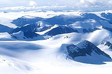
[2]: 32–33 Seasonal shifts on Ellesmere are sudden and striking: winters are long and harsh, summers short and relatively abundant, with spring and autumn being brief intervals of transition.
The fossil exhibits many characteristics of fish, but also indicates a transitional creature that may be a predecessor of amphibians, reptiles, birds, and mammals, including humans.
[51] All groups occupying the island settled on the coast, particularly those relying on maritime resources, while modern-era government-funded settlements were initially supplied by sea.
[52] With the end of the Cold War and the advent of new technologies allowing for remote interpretation of data, the overwintering population has been reduced to 62 civilians and military personnel as of 2016.
[55] In the 2013 American superhero film Man of Steel, Ellesmere Island is the site of a combined United States-Canadian scientific expedition to recover an ancient Kryptonian spaceship buried in the glacial ice pack.
[57] The 2008 documentary Exile by Zacharias Kunuk documents the experiences of Inuit families who were forcibly relocated to Ellesmere island in the 1950s to settle it for the Canadian government.
The exhibit was developed in collaboration with the National Geographic Society and features images and videos of the Arctic wolves living on Ellesmere Island.