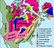
Churchill Craton
[1] A north-northwest-trending crustal segment transects from Kaminak Lake (central Hearne Domain) in the south to Yathkyed Lake (northern Hearne Domain) in the northwest, consisting of Archean supracrustal belts that preserve mostly Archean mafic to felsic volcanic rocks (greenschist-grade supracrustal and granitoids), metamorphic cooling of hornblende and Proterozoic biotite.
The Kaminak supracrustal belt preserves igneous textures including interlocking quartz and plagioclase that are intergrown with platy biotite (2.084-1.914 Ga) and stubby euhedral grains of prismatic titanite and hornblende.
Parallel to the Paleoproterozoic Hurwitz Group is massive veins of green biotite that are interpreted to have been emplaced there by a hydrothermal event accompanying a deformation along this contact area.
There is aggressive diamond exploration drilling in the south Slave Province, NWT, Churchill Craton (at the northwest corner of the Hudson Bay) and in Ontario.
The diamonds being found in the NWT were created 50 to 600 mya during cataclysmic explosions of kimberlite, a molten magma originating up to 400 kilometers beneath the Earth's surface.