Superior Craton
The Superior Craton is a stable crustal block covering Quebec, Ontario, and southeast Manitoba in Canada, and northern Minnesota in the United States.
[1] A craton is a large part of the Earth's crust that has been stable and subjected to very little geological changes over a long time.
[1] Researchers have divided the Superior Craton into many different domains based on rock types and deformation styles.
[3] Forming the core of the Canadian Shield, the Archean Superior craton is encompassed by early Proterozoic orogens.
[4] The southern side meets the Keweenawan rift, while the southernmost tip of the craton in Minnesota reaches the Central Plain orogen.
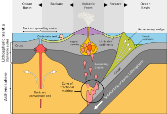
The outer arc high is formed by the flexural upward motion of the oceanic crust edge before it enters the subduction zone.
The accretionary wedges are formed from the accumulation of marine sediment scraped off from the oceanic crust before it is subducted.
The hanging walls of the thrusts slide up along the fault plane and stacks above the footwall, forming a ramp anticline or fault-bend fold.
[8] The last part is the southern region like the Minnesota River Valley, which are metavolcanic or metasedimentary subprovinces with an east–west orientation.
- Mafic-intermediate volcanic rocks[4][16][17] - Minor greywacke[4][16][17] - Amphibolite-forming metamorphism caused by tectonic accretion[4] - Diamond-containing kimberlite pipes[19] - Volcaniclastic rocks (Oxford Lake assemblage)[20] - Underlain by tonalitic, granodioritic, granitic pluton with mafic intrusion[4] - Sealed the sediment after the collision of NSS and NCS[4] - Pervasive granitic to tonalitic pluton in the central region[4] - Rifting in the southern margin[4] - Massive sulphide deposits[23] - Amphibolite and low-pressure granulite[4][25] - Migmatite and diatexite[26] - Granite[28] - Native silver deposits[4][30] - Greenstone belts intruded by granitoid pluton in the East[4] - Continental margin setting in the East[36] - Metarsedimentary successions intruded by tonalite,[4] nepheline, syenite, carbonatite[37] and granite[38] - Sanukitoids[4] - Shebandowan-Schreiber belt (Fe, Au,[45] VMS,[46] Ni)[47] - Central: Plutonic rocks and minor volcanic rocks[50] - South: Younger greywackes, conglomerate and alkaline volcanic rocks[51] - Central: Massive sulphide deposits and vein gold deposits[50] - South: Gold deposits, Cu-Zn massive sulphide deposits, intrusive Ni deposits, and minor porphyry deposits[4][52] - South: volcanic rocks[53] - Gabbroic-sill-hosted Ni-Cu sulphide deposits[4] - massive leucogranite intrusion[59] - Granulite[61] - Intrusion of diatexite,[61] syenite, granodiorite and granite[4][62] - komatiites[4] - South: massive granodioritic complex[64][65] - II: pyroxene-bearing plutonic rocks[4] - IV: metasedimentary and pyroxene-bearing pluton[66] - V: pyroxene-bearing pluton with minor tonalite[4] - VI: magnetic pyroxene-bearing pluton[67] - VII: tonalitic complex[7][6] - Epigenetic: Cu, Ni, Ag, Au, rare earth elements (REE) and limited U deposits[4] Research of the Superior Craton in the past focused on how the western part formed.
Before 2720 Ma, there were many pieces of microcontinent fragments which E-W trending conduit-like ocean crusts (with unknown extent) separates them.
Over time, it united the North Caribou Superterrane and confined the Oxford-Stull domain, which contains rock assemblages related to the continental margin and oceanic crust.
[71] The docking of the Northern Superior Superterrane is evident by the >3.5 Ga detrital zircons found in synorogenic (meaning that it forms during an orogenic event) sedimentary rocks aged <2.711 Ga.[71] The docking also initiated the eruption of shoshonitic volcanic rocks during 2710 Ma and the regional shortening.
The regional shortening had undergone folding and foliation to form right-lateral, NW-trending shear zones.
[71] Arc-related magmatic activities sustained in other areas of the southern North Caribou Superterrane margin at <2710 Ma.
[71] Two types of models were proposed to illustrate the process accretion with distinctive subduction polarity: Sanborn-Barrie and Skulski (2006)[73] suggested that the accretion was achieved by the northeastward subduction of the Western Wabigoon Terrane underneath the Winnipeg River Terrane.
[1] The northward direction of the subduction is evident due to the ceased arc magmatism in Winnipeg River superterrane at about 2695 Ma.
This also trapped the clastic sediments fluxing into the belt, marking its transition from an accretionary wedge to a foreland basin.
[71] The northward direction of the subduction is proven by the peraluminous granitoid magmatism in the southern margin of the Abitibi terrane, as well as the isotopic signature of the ancient crust underneath it.
[76] However, the study of seismic reflection images by Percival et al.[71] reveals that Minnesota River Valley Terrane positions at the bottom of a thrust sequence, providing evidence that it is an oceanic slab.