Cincinnati Arch
It existed as a positive topographic area during late Ordovician through the Devonian period which stretched from northern Alabama northeastward to the southeastern tip of Ontario.
Fossils from the Ordovician are commonplace in the geologic formations which make up the Cincinnati Arch and are commonly studied along man made roadcuts.
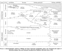
The Edenian contains these formations: Kope, Clays Ferry, Garrard Siltstone, Catheys, Inman, Fairview, and Leipers Limestone.
[3] The Maysvillian is the second oldest stage containing these formations: Dillsboro, Kope, Bellevue, Fairview, Grant Lake Limestone, Ashlock, Calloway Creek, Leipers, Fernvale, and Arnheim.
The Richmondian contains: Bull Fork, Saluda, Whitewater, Drakes and parts of Grant Lake Limestone as well as Fernvale and Arnheim.
[5] Fossiliferous limestone is made up of beds of previously organic matter that has undergone permineralization and fossilized forming large mats of calcite and aragonite rich rock.
Since roadcuts are typically made quite steep they allow scientists to view changes in prehistoric conditions through millions of years by studying the differences between layers in a vertical column.