Circle Drive
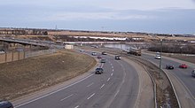
[1] Most of the route is a fully-controlled access freeway, however the segment between Airport Drive and Millar Avenue has at-grade intersections.
The proposed road was officially named "Circle Drive" at a special city council session on May 4, 1959,[3] and by the fall of 1960 a route had been formalized which planners mostly adhered to for the remainder of the project.
The first portion of the southeast leg to be built was from 8th Street south to the city limits where it met a realigned Highway 11.
The next portion of the roadway completed was the northeast quadrant, from College Drive to Warman Road, connecting the two extant sections.
Also, partially in preparation for the extension of the freeway (as well as residential and commercial development), an interchange at Clarence Avenue South was added in the late 2000s.
Industrial area to the Holiday Park neighbourhood, travelling through property annexed from the Saskatoon Golf and Country Club.
[10] However, record rainfall, high water tables and an early snowfall made that deadline unfeasible, and the roadway ultimately did not open until July 31, 2013.
Some roadways in Montgomery Place and Holiday Park Industrial were also realigned and the at-grade intersection at Circle and Clancy Drive was also revised.
[12] Additional road revisions were required as part of the project: 11th Street West, westbound from the new interchange with Circle, was replaced with the 11th Street West Bypass, aligned further north from the original road, which was converted into a cul-de-sac; this, in turn, opened up space for new multi-family residential development in the mature Montgomery Place community.
Development of the Circle Drive/Valley Ridge interchange also required the permanent closure of the Fletcher Road access point into South West Industrial via Dundonald, leading to city planners adding a new roadway, Dawes Avenue, to provide an extra access to 11th Street and, in turn, Circle Drive.
Although the circle is now "closed", the City of Saskatoon is investigating future improvements to older parts of the freeway, including revisions to the aged Idylwyld Drive North/Circle Drive interchange and finding ways to deal with traffic congestion along the non-freeway "42nd Street" (Warman Road to Avenue C) section of the road.
As of October 2013 the City's Projected Growth Concept Plan map shows a proposed interchange at Airport Drive.
The first such construction of its kind in Saskatchewan, motorists found it difficult to navigate, leading to local media airing advisories on how to use it.
The site of many accidents over the years, and dubbed the most accident-prone location in the city,[20] the circle was ultimately dismantled in the 1980s and replaced with a split at-grade intersection in anticipation for a standard diamond interchange that was constructed in the 1990s.