Climate of Buenos Aires
Summers are hot and humid with frequent thunderstorms while winters are cool and drier with frosts that occurs on average twice per year.
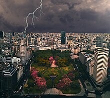
The hot temperatures and high insolation in the summer months form a low pressure system called the Chaco Low over northern Argentina, generating a pressure gradient that brings moist easterly winds to the city – because of this, summer is the rainiest season.
The coastal location results in a strong maritime influence, causing extreme temperatures (hot or cold) to be rare.
[4][5] Due to the maritime influences from the adjoining Atlantic Ocean,[3] its climate is temperate with extreme temperatures (both hot and cold) being rare.
[4] The South Pacific High is the origin of polar air masses that are responsible for the coldest temperatures and result in clear and very dry conditions.
[7] Although it is polar maritime (this is a cool, moist air mass that forms from oceans located in the sub-Antarctic and Antarctic regions at the southern tip of South America), it becomes modified as it passes over the South American continent, becoming drier as it arrives at Buenos Aires.
[11] Being located in the Pampas, the weather is variable due to the contrasting air masses and frontal storms.
[12][13][14] Often, the passage of the Pampero winds occurs as a cold front passes through, leading to strong gusts from the south or southeast, a decrease in humidity and temperature, and an increase in the atmospheric pressure.
[13] When the cold Pampero winds meet with warm humid air from the north, thunderstorms are produced.
[19][20][21][22] Flooding impacts the neighbourhoods La Boca and Barracas which are in the southern parts of the city, more low-lying and inhabited by poor people (of low socioeconomic status).
[24] On average, Buenos Aires is warmer than the surrounding areas by 1.5 to 3.5 °C (2.7 to 6.3 °F) owing to the urban heat island.
[25] The El Niño–Southern Oscillation is a major factor in the variation of annual precipitation within Buenos Aires and the Pampas, particularly during spring and summer.
[31] In contrast, hot humid air from the north produces sultry days;[12] the highest temperature recorded in spring is 36.8 °C (98.2 °F) on 27 November 1955.
[41] These severe storms can damage cars, houses and disrupt public services such as transportation and collection and disposal of urban solid waste.
[3] This is due to the city center having higher temperatures than the surrounding areas owing to the urban heat island effect.
[16][17][18] Winters are cloudy while relative humidity is very high, often 90% or higher, making the weather dull, grey and cool.
[7] These warm air masses can bring sunny weather, particularly during the afternoon when they come from the north or northwest as a result of a trough located in central Argentina.
[7] On the other hand, warm air masses from Brazil bring humid conditions, featuring high humidity with high cloud cover that is typical of a warm front of a frontal system and typical of tropical maritime air.
[48] Warm, humid air penetrates the city, higher solar radiation and frequent synoptic weather disturbances from the west occur during the end of the winter.