Climatic regions of Argentina
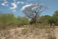
Northern parts of the country[note 2] are characterized by hot, humid summers with mild, drier winters, and highly seasonal precipitation.
Mesopotamia, located in northeast Argentina, has a subtropical climate with no dry season and is characterized by high temperatures and abundant rainfall because of exposure to moist easterly winds from the Atlantic Ocean throughout the year.
Central Argentina, which includes the Pampas to the east, and the Cuyo region to the west, has a temperate climate with hot summers and cool, drier winters.
In the Cuyo region, the Andes obstruct the path of rain-bearing clouds from the Pacific Ocean; moreover, its latitude coincides with the subtropical high.
Patagonia, in the south, is mostly arid or semi–arid except in the extreme west where abundant precipitation supports dense forest coverage, glaciers, and permanent snowfields.
In general, Argentina has four main climate types: warm, moderate, arid, and cold, all determined by the expanse across latitude, range in altitude, and relief features.
[7][8] Consequently, there is a wide variety of biomes in the country, including subtropical rain forests, semi-arid and arid regions, temperate plains in the Pampas, and cold subantarctic in the south.
[2] This year-round rainfall occurs because most of the region lies north of the subtropical high pressure belt even in winter, exposing it to moist easterly winds from the Atlantic Ocean throughout the year.
[20][21]: 12 [25] The mean January temperature throughout most of the region is 25 °C (77 °F) except in the uplands of Misiones Province where they are lower owing to its higher elevation.
[36] The interaction between the South Atlantic High and the Chaco Low generates a pressure gradient that brings moist air from the east and northeast to eastern coastal and central regions of Argentina.
[36][52] During summer, the interaction between the South Atlantic High and the Chaco Low brings northeasterly and easterly winds that carry moisture to the region, particularly in the northern parts.
[21][50][51]: 20 [53] The Chaco Low attracts air masses from the South Pacific High, creating a dry and cold wind, particularly during winter.
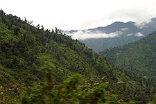
[54] As moist air reaches the eastern slopes of the mountains, it rises and cools adiabatically, leading to the formation of clouds that generate copious amounts of rain.
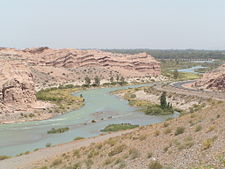
[57][58] Valleys in the southern parts of the region are drier than valleys in the north due to the greater height of the Andes and the Sierras Pampeanas on the eastern slopes compared to the mountains in the north (ranging from 3,000 to 6,900 m (9,800 to 22,600 ft)), presenting a significant orographic barrier that blocks moist winds from the Atlantic and Pacific Oceans.
[52] The area further west is the Puna region, a plateau with an average altitude of 3,900 m (12,800 ft) that is mostly a desert due to the easterly winds being blocked by the Andes and the northwest extension of the Sierras Pampeanas.
[52][53][64] During an El Niño year, westerly flow is strengthened, while moisture content from the east is reduced resulting in a drier rainy season.
[57][58] In the Yungas jungle to the east, the climate is hot and humid with temperatures that vary significantly based on latitude and altitude.
[59] In contrast, the Zonda wind, which occurs more often during the winter months, can raise temperatures up to 35 °C (95 °F) with strong gusts, sometimes causing crop damage.
[47] Western parts of La Pampa Province (as shown in map) also belong in this region, having similar climatic and soil characteristics to it.
[67] The Andes prevent rain-bearing clouds from the Pacific Ocean from moving in, while its latitude puts it in a band of the sub-tropical high pressure belt keeping the region dry.
[91] Occasionally, tropical air masses from the north may move southward, providing relief from the cool, damp temperatures.
[106][107] The exception is the Bosque Andino Patagónico, a forested area located in the extreme west and southern parts of Tierra del Fuego Province, which has a humid, wet, and cool to cold climate.
[110] The Andes play a crucial role in determining the climate of Patagonia because their north–south orientation creates a barrier for humid air masses coming from the Pacific Ocean.
[111][109] South of 52oS, the Andes are lower in elevation, reducing the rain shadow effect in Tierra del Fuego Province, allowing forests to thrive on the Atlantic coast.
[109] Northeastern areas, along with southern parts of the region, are influenced by air masses from the Atlantic Ocean, resulting in precipitation being more evenly distributed throughout the year.
[109] The influence of the Pacific Ocean, general circulation patterns, and the topographic barrier caused by the Andes, results in one of the strongest precipitation gradients in the world.
[114] Much of northwestern Patagonia in the Andes, corresponding to the northern parts of the Bosque Andino Patagónico region, receives abundant precipitation in winter with occasional droughts in summer, allowing it to support forests with dense coverage.
[114][119] The Atlantic Ocean moderates the climate of coastal areas resulting in a lower annual and daily range of temperatures.
[107] The annual range of temperatures in Patagonia is lower than in areas in the Northern Hemisphere at the same latitude owing to the maritime influences of the sea.
[109][121] The reading of 30.8 °C (87.4 °F) in Río Grande located in Tierra del Fuego Province on 4 February 2019 is believed to be the southernmost recorded instance where temperatures exceed 30 °C (86 °F).