Lofoten
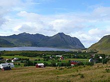
Lofoten has distinctive scenery with dramatic mountains and peaks, open sea and sheltered bays, beaches, and untouched lands.
The archipelago experiences one of the world's largest elevated temperature anomalies relative to its high latitude.
There have been many attempts to research the backgrounds and meanings of both the names Lofoten and Ofoten, which has led to many theories, but no definite information.
The archipelago looks like a closed wall when seen from elevated points around Bodø Municipality or when arriving from the sea, some 100 kilometres (62 miles) long, and 800–1,000 metres (2,600–3,300 feet) high.
Iron Age agriculture, livestock, and significant human habitation can be traced back to c. 250 BC.
It existed in the early Viking Age, maybe earlier, and was located on the southern coast on eastern Lofoten, near today's village Kabelvåg in Vågan Municipality.
Bergen in southwestern Norway was for a long time the hub for further export of cod south to different parts of Europe, particularly so when trade was controlled by the Hanseatic League.
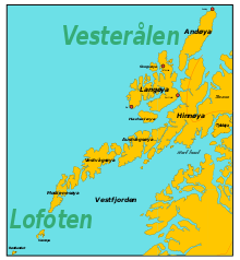
Lofoten encompasses the municipalities of Vågan, Vestvågøy, Flakstad, Moskenes, Værøy, and Røst.
Between the mainland and the Lofoten archipelago lies the vast, open Vestfjorden, and to the north is the Vesterålen district.
The Lofoten Islands are characterised by their mountains and peaks, sheltered inlets, stretches of seashore and large virgin areas.
The famous Moskstraumen (Malstrøm) system of tidal eddies is located in western Lofoten, and is indeed the root of the term maelstrom.
[10] Some of the high relief and irregular surfaces of Lofoten has been attributed to etching that took place during the Mesozoic Era.
This is the result of erosion acting on a landscape that has been uplifted along NE–SW-trending faults in the margins of Lofoten while the interior axis has remained more stable.
[13] Approximately 70% of all fish caught in the Norwegian and Barents seas use its islands' waters as a breeding ground.
There are no native conifer forests in Lofoten, but some small areas with private spruce plantations.
Some 27,000 hectares (100 sq mi) of marine waters along the north-western coasts and fjords of the Lofoten Islands have been designated an Important Bird Area (IBA) by BirdLife International (BLI) because it supports overwintering populations of common eiders and yellow-billed loons.
[8] The birds once mistaken for the extinct great auk turned out to be some of the nine king penguins released around Norway's Lofoten Islands in August 1936, there until at least 1944.
At 1 metre (3 feet 3 inches) depth in the sea near Skrova, water temperatures vary from a low of 3 °C (37 °F) in March to 14 °C (57 °F) in August, some years peaking above 17 °C (63 °F).
Skrova and nearby Svolvær are among those places in North Norway that can record what Norwegians know as "tropical nights" when the overnight low does not go below 20 °C (68 °F).
Vestvågøy with the town Leknes has lowland in the interior of the island with mountains nearby; winters here are slightly colder and much wetter than at Skrova, while summers are drier and comparable.
It has 24 hours of daylight in the summer and has Alpine-style ridges, summits, and glaciers, but at a height of less than 1,200 metres (3,900 feet).
There is a dedicated cycling ferry that sails between Ballstad and Nusfjord, allowing cyclists to avoid the long, steep Nappstraum tunnel.
[26][full citation needed] The European road E10 connects the larger islands of Lofoten with bridges and undersea tunnels.
[29] Artists who have participated include Kjersti Andvig, Michel Auder, A K Dolven, Ida Ekblad, Elmgreen & Dragset, and Lawrence Weiner.
Other artists whose work has been associated with Lofoten include Adelsteen Normann, Otto Sinding, Christian Krohg, Theodor Kittelsen, Lev Lagorio,[37] Ernst Wilhelm Nay and Ingo Kühl.