Cromwell Gorge
Long-associated with gold mining, orchards and the production of stone fruit, the gorge (including part of old Cromwell) was flooded in the early 1990s to form Lake Dunstan behind the hydroelectric Clyde Dam.
[2] The former Otago Central Railway which traced the river through the gorge from Clyde was removed, while State Highway 8 was realigned above the newly-formed lake.
[4] The Cromwell Gorge formed in response to the uplift of the Dunstan and Cairnmuir Mountains and simultaneous antecedent incision by the Clutha River.
The Cromwell Gorge is the entrance to the Upper Clutha Valley and was historically an important thoroughfare for early Māori moa hunters, and later pastoralists and gold miners in the late nineteenth century.
The Cromwell Gorge is dominated by the characteristic rocky tors and craggy outcrops of the Haast Schist Group; grey quartzofeldspathic metagreywacke interlayered with micaceous meta-argillite and greenschist formed during the Rangitata Orogeny.
[12][13] Investigations have found that geologically-recent deformation associated with the Dunstan Fault has extended south-west towards Clyde, rather than being translated along the southern margin of the Cairnmuir Mountains.
[15] The arrival of humans in Central Otago resulted in particularly extensive changes in vegetation as Māori hunter-gatherers used clearance fires improvidently.
Initial woody cover included totara (Podocarpus hallii) and beech forest (Nothofagus menziesii) over what is now a treeless Central Otago.
On the former valley floor of the Cromwell Gorge, low tussock grassland of several varieties dominated, while manuka, kānuka and matagouri scrub patched the lower slopes.
[19] Today in spring and summer the gorge blossoms with wild flowers: the purple of thyme, the blue of Vipers bugloss, the red of Spur valerian, and the yellows of Californian poppy and stone crop.
[20] The first settlers in the region were the Māori as they travelled through Central Otago en route to the West Coast on pounamu expeditions, as well as in search of seasonal food resources.
[32][33] Evidence for Māori occupation of specific sites in the Cromwell Gorge was well-documented during the Clutha Valley Archaeological Project resulting from the decision to build the Clyde Dam.
[36] The trek from the Mataura River in Southland to Waitaki was some 400 km (250 mi) distance, climbing mountain passes in excess of 1,000 m (3,300 ft) – something Chalmers was blissfully ignorant of ahead of his expedition.
[36][29] In a letter to historian Herries Beattie, Chalmers recorded his account of the journey (some fifty seven years after the fact) stating that the shortest way back to Southland would be to build a flax fibre mokihi or raft and ride it all the way down the Clutha River.
The initial rush to the gorge, referred to as the Dunstan goldfield, began on 16 August 1862 following an announcement in the Otago Daily Times that two men, Hartley and Reilly, had discovered 87 lb (1044 t oz) of gold.
[47] European miners had departed in their droves for more lucrative goldfields in Marlborough and the West Coast, opening the door for Chinese mining immigrants to come directly from China, particularly Guangdong province.
[20] This was made more problematic due to the manner by which they were initially invited to New Zealand; the Chinese regarded themselves as temporary visitors seeking gold.
[20] Orchards, grown on both sides of the Clutha River, primarily produced stone fruits (particularly apricots, cherries, nectarines, peaches, plums) as well as a number of varieties of apples and pears.
[20][65] Imported from Australia, the first trees Annan planted were a diverse mix to test what would be most suitable for the challenging Central Otago climate and included citrus, almond, walnut, cherry, apricot, apple, pear, peach, nectarine, quince and grape.
[72][73] The impact on existing activities from any scheme was recognised from the outset: Any further Clutha Valley development poses a very complex problem as there are considerable areas of better lands, orchards, allied industries, communication routes, closer settlement, and whole townships or effects on townships and local bodies to be taken into account.Protests that the dam would flood established orchards, the railway, State Highway 8 as well as parts of Cromwell[74] were all ignored with the high dam becoming part of the National Government's Think Big policy.
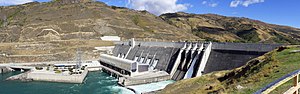
A cable crane attached to pylons delivered the majority of the 1.2×10^6 m3 (42×10^6 cu ft) of concrete required to build the dam and its associated powerhouse.
[39] The filling of the Clyde Dam resulted in the loss of significant sites of cultural interest in the Cromwell Gorge and other areas inundated by Lake Dunstan.
Knowing this would be the case, the Ministry of Works commissioned archaeological surveys of the gorge and surrounding areas that would be impacted by the filling of Lake Dunstan.
[77][39] Perhaps the greatest site of interest of the entire ten-year project was the excavation of Cromwell's Chinatown at the confluence of the Clutha and Kawarau Rivers.
[39] Ritchie (1989)[77] presented a compilation of 617 sites of archaeological significance, 85 of which were submerged in the Cromwell Gorge due to the filling of Lake Dunstan.
[39] Large-scale landslides are a common feature in the Cromwell Gorge and represent a significant geological hazard following the impoundment of the Clutha River behind the Clyde Dam.
Thirteen large-diameter tunnels extend into the toes of several landslides in order to drain groundwater which otherwise lubricates the basal shear zone.
On the true left bank of Lake Dunstan runs State Highway 8, a single carriageway linking Clyde to Cromwell via Deadman's Point Bridge.
[109] Although it does not form part of the existing Otago Central Rail Trail, it is a purpose-built extension on the opposite true right side of the gorge, running along the foot of the Cairnmuir Mountains.
[111][112] The 5 m (16 ft) sculpture by artist Dan Kelly is fashioned from recycled steel, and will stand as guardian to the gorge and the township of Clyde below.