Coastal zone color scanner
The coastal zone color scanner (CZCS) was a multi-channel scanning radiometer aboard the Nimbus 7 satellite, predominately designed for water remote sensing.
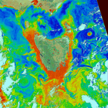
The "color" of the ocean in CZCS images comes from substances in the water, particularly phytoplankton (microscopic, free-floating photosynthetic organisms), as well as inorganic particulates.
By recording images over a period of years, scientists also gained a better understanding of how the phytoplankton biomass changed over time; for instance, red tide blooms could be observed when they grew.
Raw data from the scanner were transmitted, at an average bit rate of 800 kbit/s, to the ground station, where they were saved on magnetic tape.
The archive was one of the first instances of a system that provided a visual preview ("browse") of images, which assisted in ordering data.
CZWS was the first satellite ocean color sensor, and after it stopped observing in 1986, there was a 10-year gap in records until Japan launched the Ocean Color Temperature Scanner (OCTS) in 1996, and the United States launched the Sea-viewing Wide Field-of-view Sensor (SeaWiFS) in 1997.
Current instruments that provide ocean color data include Aqua-MODIS, Copernicus Sentinel 3 Ocean and Land Colour Instrument (OLCI), and NOAA's Visible Infrared Imaging Radiometer Suite (VIIRS) on board the Joint Polar Satellite System (JPSS) satellites.