Collocation (remote sensing)
In principle, most collocation problems can be solved by a nearest neighbor search, but in practice there are many other considerations involved and the best method is highly specific to the particular matching of instruments.
The second consideration is the instrument footprint, which can range from something approaching a point measurement such as that of a radiosonde, or it might be several kilometers in diameter such as that of a satellite-mounted, microwave radiometer.
In theory, collocations can be performed by inverting the determining equations starting from the desired time period.
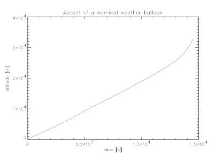
Radiosondes are particularly important for collocation studies because they measure atmospheric variables more accurately and more directly than satellite or other remote-sensing instruments.
Compare this with the values shown in the histogram which compiles all of the radiosonde launches from the Polarstern research vessel over a period of eleven years between 1992 and 2003.
A specific point in both physical position and time is easy to locate within the grid and interpolation performed between the nearest neighbors.
Since measurements within a single scan track are laid out in an approximately rectangular grid, bilinear interpolation can be performed.
This technique works better with derived quantities rather than raw brightness temperatures since the scan angle will already have been accounted for.
A method commonly used for this particular instrument, as well as SSM/I, is a simple daily average within regularly gridded, spatial bins .
[4] To collocate measurements of a medium- to long-lived atmospheric tracer with a second instrument, running trajectories can considerably improve the accuracy.
It also simplifies the analysis somewhat: a trajectory is run both forwards and backwards from the measurement location and between the desired time window.
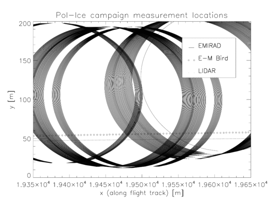
Collocations of sea ice thickness and brightness temperatures taken during the Pol-Ice Campaign are an excellent example since they illustrate many of the most important principles as well as demonstrating the necessity of taking into account the individual case.
The Pol-Ice campaign was conducted in the N. Baltic in March 2007 as part of the SMOS-Ice project in preparation for the launch of the Soil Moisture and Ocean Salinity satellite.
Brightness temperatures were measured with the EMIRAD L-band microwave radiometer [5] carried on board an airplane.
[6] The map above shows the flight tracks of both instruments which were approximately coincident but obviously subject to pilot error.