Colorado State Highway 82
The pass is closed during the winter months, isolating Aspen from the east and making Highway 82 the only way to reach the popular ski resort town by road.
The increased traffic resulting from Aspen's economic rebirth as a resort town has required high-occupancy vehicle lanes, bypasses and the replacement of at least one old bridge.
At 23rd Street, Highway 82 turns southeast to follow South Glen Avenue, paralleling the adjacent Rio Grande rail trail.
After passing Rosebud Cemetery on the west side, Highway 82 turns more to the southeast and draws alongside the Roaring Fork as it reaches the city limits.
[5] Following the river's bend, the road returns to its southern heading as most development focuses around Glenwood Springs Municipal Airport on the opposite bank.
[9] A half-mile (1 km) beyond that junction, at the headquarters of the Garfield County Road and Bridge District, the highway begins a long stretch with a southerly heading.
[18] Subdivisions begin to increase in the surrounding valley and the road soon turns to the south again as it passes a built-up area and then crosses the Roaring Fork.
[29] As Aspen–Pitkin County Airport appears on the west of the road, three miles (4.8 km) south of Woody Creek, the roadways merge as development around the highway increases.
It bends to the southeast to cross the new Maroon Creek Bridge, with the original, listed on the National Register of Historic Places, immediately to its south.
The buildings gradually change from residential to commercial, and at Mill Street Highway 82 passes one of Aspen's major landmarks, the Hotel Jerome, also listed on the National Register.
The remaining log cabins and other structures of the ghost town of Independence, also listed on the National Register, are visible in the valley below at 13.5 miles (21.7 km) east of Aspen.
As it assumes that heading it passes the other set of gates, just west of the very small settlement of Everett, near where Lake Creek's North Fork joins the main stream.
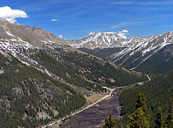
[44] A mile past that bend Highway 82 reaches the small community of Twin Lakes,[45] also listed on the National Register as a historic district as an early tourist town.
They are generally either unaware of the restriction and following routes plotted by their GPS devices, or aware of it and willing to risk the fine for the sake of the time and distance saved.
Prospectors who had missed out on the earlier mining boom that built Leadville began to head west, drawn by reports of vast untapped silver deposits in the Roaring Fork Valley just beyond the Continental Divide.
They began crossing what was then known as Hunter Pass,[53] in defiance of an order from Governor Frederick Walker Pitkin not to do so until the federal government had negotiated a peace treaty with the Ute people.
The city's rapid growth fostered a race to make the first rail connection, which displaced the toll road as the primary route to Aspen within a decade.
[53] The tolls, 25 cents for saddle horses and twice that for stages ($8 and $16 in modern dollars respectively[56]) were primarily spent hiring a large crew of men who kept the pass clear in winter with snowshovels.
In deep enough snow passengers switched to sleighs; in summer, dogs ran in advance to warn oncoming traffic through the pass itself as the stages took the switchbacks at full speed.
A year later the railroad had laid 250 miles (400 km) of track from Colorado Springs to Leadville and crossed the Continental Divide via the Hagerman Tunnel, then the world's highest.
To overcome the Midland's lead, they built a narrow-gauge line on the north side of the Roaring Fork, today the route of the Rio Grande Trail.
Both the gauge and the elimination of the Maroon Creek crossing, which was causing complications for the Midland, saved considerable time, and the Rio Grande managed to bring the first train to Aspen in October 1887.
In 1927 it rebuilt the old stage road over Independence Pass to Twin Lakes and designated it part of Highway 82, closing it in winters to avoid the maintenance costs.
While the ranchers were able to get their products to market faster,[60] the new road would catalyze Aspen's economic revival in an industry that had not existed when the Depression began: recreational downhill skiing.
Coincidentally, Walter Paepcke, head of the Container Corporation of America, visited Aspen with his wife Elizabeth in the late 1940s, and found it an ideal place to establish a music festival they were planning.
Its founder, environmental activist Bob Lewis, had been organizing efforts to revegetate the slopes alongside Highway 82 going up to the pass, in order to repair damage that had been done the road's construction.
In cooperation with the Highway Department, the U.S. Forest Service and the county, the IPF rebuilt a curve along the road near the Weller Lake trailhead that year.
[71] In a departure from the usual practice, the diamonds were painted in the right lanes rather than the left, so that Roaring Fork Transportation Authority (RFTA) buses could get to and from their stops more easily.
Two years after the first one the IPF began the project Lewis had always envisioned for it—restoring the Top Cut, the 1.5-mile (2.4 km) section just below the pass on the east, where the environmental damage, especially erosion, had always been most evident.
Right-of-way easements have been acquired for a new two-lane parkway, as authorized by voters, that would cross the Holden/Marolt property via a 400-foot (120 m) cut and cover tunnel to reconnect to the existing highway at Main and Seventh streets.