Columbus Day storm of 1962
On October 3, the system strengthened into a tropical storm and was given the name Freda, before becoming a typhoon later that day, while moving northeastward.
The storm quickly intensified, reaching its peak as a Category 3-equivalent typhoon on October 5, with maximum 1-minute sustained winds of 115 mph (185 km/h) and a minimum central pressure of 948 millibars (28.0 inHg).
Making a turn to the northeast, Freda maintained typhoon-status winds for several more days, before weakening into a tropical storm on October 9, as it started experiencing the effects of cold air.
[5] The extratropical low redeveloped intensely off the coast of Northern California, due to favorable upper-level conditions, producing record rainfall across the San Francisco Bay Area that delayed some games in the 1962 World Series between the San Francisco Giants and the New York Yankees.
There was little central pressure change until the cyclone passed the latitude of Astoria, Oregon, at which time the low began to degrade.
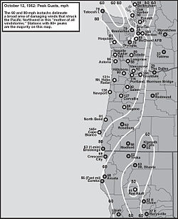
[8] At the Naselle Radar Station in the Willapa Hills of southwest Washington, a wind gust of 160 mph (260 km/h) was observed.
[7] At Corvallis, Oregon, an inland location in the Willamette Valley, one-minute average winds reached 69 miles per hour (111 km/h), with a gust to 127 mph (204 km/h), before the station was abandoned due to "power failure and instruments demolished".
In Vancouver, Washington around 9 miles north of downtown Portland, a peak gust of 92 mph (148 km/h) was observed at Pearson Field.
Many anemometers, official and unofficial, within the heavily stricken area of northwestern Oregon and southwest Washington were damaged or destroyed before winds attained maximum velocity.
For example, the wind gauge atop the downtown Portland studios of KGW radio and TV recorded two gusts of 93 mph (150 km/h), just before flying debris knocked the gauge off-line[9] shortly after 5 p.m. For the Willamette Valley, the lowest peak gust officially measured was 86 mph (138 km/h) at Eugene.
For Pacific Northwest windstorms in the 20th century, the runner up was the infamous October 21, 1934, gale, which caused 22 fatalities, mostly in Washington.
[11] The Metropolitan Life Insurance Co. (now MetLife) named the Columbus Day Storm the nation's worst natural disaster of 1962.
[12] In Central and Northern California, all-time record rains associated with the atmospheric river along the cold front caused major flooding and mudslides, particularly in the San Francisco Bay Area.
Livestock suffered greatly due to the barn failures: the animals were crushed under the weight of the collapsed structures, a story that was repeated many times throughout the afflicted region.
Seven-month-old TV station KATU did not receive any damage at its Livingston Mountain site, 6 miles (9.7 km) north of Camas, Washington.
The heavy-duty design of the radio towers on Portland's West Hills today, with extensive and robust guy cables, is a direct result of the lessons learned from the 1962 catastrophe.
East of Salem, the wind destroyed a historic barn that served as a clandestine meeting place by pro-slavery Democratic members of the state Legislature in 1860.
[citation needed] The Oregon State Beavers–Washington Huskies college football game went on as scheduled Saturday, October 13 in Portland, in a heavily damaged Multnomah Stadium.
[16] The Huskies came from behind to beat the Beavers 14–13, despite a strong performance by quarterback Terry Baker, who would win the Heisman Trophy later that year.
The Willapa Hills and southern portion of the Olympic Peninsula incurred the worst damage in the state, losing entire stands of trees.
[18] The storm weakened as it traveled north into British Columbia, with peak gusts measured at 90 miles per hour (140 km/h).

Tropical storm (39–73 mph, 63–118 km/h)
Category 1 (74–95 mph, 119–153 km/h)
Category 2 (96–110 mph, 154–177 km/h)
Category 3 (111–129 mph, 178–208 km/h)
Category 4 (130–156 mph, 209–251 km/h)
Category 5 (≥157 mph, ≥252 km/h)
Unknown