Costa Chica of Guerrero
Geographically, it consists of part of the Sierra Madre del Sur, a strip of rolling hills that lowers to coastal plains to the Pacific Ocean.
The region is one of the poorest in Mexico, with an economy based on subsistence agriculture and fishing, with some commerce, especially along Highway 200, which parallels the coast.
The Costa Chica of Guerrero is a coastal region beginning just southeast of Acapulco, and ending at the Oaxaca state border to the south.
[7] The Costa Chica (of both Guerrero and Oaxaca) is one of two zones in Mexico with significant Afro-Mexican populations, with the other being in the state of Veracruz.
[9] The historic Afro-Mexican communities were known for building round mud huts with thatched roofs, the design of which can be traced back to what are now Ghana and the Ivory Coast.
[10] The culture was featured in a documentary called Santa Negritud by La Maga Films sponsored by Susana Harp .
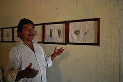
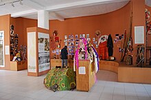
[11] The history and culture of these people is also the focus of a museum in Cuajinicuilapa, called the Museo de las Culturas Afromestizas .
The Amuzgo also populated the coast but Mixtec expansion, the Spanish conquest, and later African migration pushed them into the mountains.
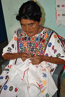
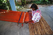
The most traditional garments are made from a local cotton called coyuche, which is grown, cleaned, spun, dyed then woven.
[3] Archeological excavation in the region has been spotty with only preliminary evaluation starting from the 1930s, so information on the pre Hispanic history of this area is limited.
Sites have been identified in the municipalities of Azoyú, Juchitán, Marquelia, Ometepec, San Luis Acatlán and Tecoanapa.
Highland sites include Piedra Labrada, Los Zapotales, La Mira, Arcelia del Progreso and Yoloxóchitl all above 650 meters above sea level.
[13][2] During the Spanish conquest of the Aztec Empire, Pedro de Alvarado conquered the area in 1522, founding the town of Acatlán the same year.
During the rest of the 16th century, much of the indigenous population was decimated, primarily due to new infectious diseases carried by colonists; they also suffered from war and overwork.
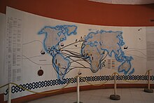
During the colonial period, the Spanish imported a total of about 200,000 African slaves from West Africa to Mexico over three centuries.
Working on sugar plantations, in mines and in ranching, slaves who escaped migrated to the isolated Costa Chica region, where they found refuge.
[3] In 1813, José María Morelos y Pavón came through the region, entering from Oaxaca to take the area during the Mexican War of Independence on his way to Acapulco.
[16][17] At the end of the war, the region became part of the Capitanía General del Sur, with Vicente Guerrero, an Afro-Mexican, as its head.
Municipalities in the region that suffered damage include Ometepec, Xochistlahuaca, Copala, Cruz Grande and Marquelia.
Another important folk dance is called Los Diablos (The Devils), which is performed by a group of men in masks with long beards.
One type of corrido simultaneously glorifies and chastises “hombres bragado” (“ballsy men”) who risk their lives, often with violence, to defend local notions of honor and glory.
[2] The Costa Chica is characterized by high indices of socio-economic marginalization; it is one of the poorest regions in the state of Guerrero.
[2] Since the late 20th century, more men have migrated out of the region to find work, mostly in tourism centers in Guerrero, such as Acapulco, and some other states in Mexico.
[3][2] The main economic activities are agriculture, livestock and fishing, with corn being the most important crop, grown by households for their own consumption.
Commerce in this area has been helped by the 1995 construction of highway linking Xochistlahuaca and Tlacoachistlahuaca with the regional commercial center of Ometepec.
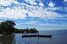
Thirteen of these are completely dependent on fishing, with San Marcos and Marquelia having other economic activities, such as commerce and services.
The fishing communities include San José Guatemala, Boca del Río, Colonia Juan Nepmuceno Álvarez, Barra de Copala, Marquilia, Playa La Bocana, Barra de Teconapa, Punta Maldonado, Nuevo Tecomulapa, Las Ramaditas, San Marcos, Pico del Monte and Las Peñas.
It has sunk cement blocks designed to allow the growth of coral to form artificial reefs and accompanying fish and shellfish.
Most economic activity is based on fishing, but there are some palapas and food service at the Pico del Monte beach, which is next to where the lagoon opens to the sea.
Unlike other beaches in the area, this is relatively developed with houses, restaurants and hotels made of cinderblock and concrete, painted in bright colors.