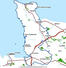
Cotentin Peninsula
The largest town on the peninsula is Cherbourg-en-Cotentin, a major cross-channel port on the north coast, with a population of approximately 120,000.
The oldest stone in France is found in outcroppings on the coast of Cap de la Hague, at the tip of the peninsula.
The town known today as Coutances, capital of the Unelli, a Gaulish tribe, acquired the name of Constantia in 298 during the reign of Roman emperor Constantius Chlorus.
As a result of his conquests, the Cotentin Peninsula was included theoretically in the territory of the Kingdom of Brittany, after the Treaty of Compiègne (867) with the king of the Franks.
[8] Other names are typical: all those ending with -tot (Quettetot..) from topt "site of a house" (modern -toft), -bec (Bricquebec, Houlbec..) from bekkr "brook", "stream", etc.
Henry, as count of the Cotentin, established his first power base there and in the adjoining Avranchin, which lay to the south, beyond the River Thar.
[9] During the Hundred Years War, King Edward III of England landed in the bay of La Hougue, and then went to the Church of Quettehou in Val de Saire.
The town of Valognes was, until the French Revolution, a provincial social resort for the aristocracy, nicknamed the Versailles of Normandy.
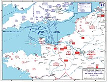
Little now remains of the grand houses and châteaux; they were destroyed by combat there during the Battle of Normandy in World War II.
The genetic history of the modern inhabitants of Cotentin Peninsula was studied by the University of Leicester in 2015-2016 to determine the extent of Scandinavian ancestry in Normandy.
The roads used for transport of nuclear waste have been blocked many times in the past by environmental action group Greenpeace.
Due to its comparative isolation, the peninsula is one of the remaining strongholds of the Norman language, and the local dialect is known as Cotentinais.
The Norman language writer Alfred Rossel [fr], native of Cherbourg, composed many songs which form part of the heritage of the region.