Course of the Klamath River
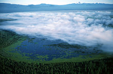
The Lost River enters from the left via a series of agricultural ditches and canals (formerly, all of its water emptied into Tule Lake).
Exiting the dam 200 miles (320 km) from the mouth, the river bends sharply north then south around a ridge and receives Fall Creek from the right as it passes the town of Copco.
[6] The river receives Jenny Creek, a much larger tributary, which is formed by streams draining out of Howard Prairie Lake nearly 20 miles (32 km) to the north.
It then turns west, and with the massive bulk of Dry Lake Mountain looming to the north, the river receives Horse Creek from the right after passing the town of the same name.
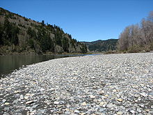
It then turns south and then west, whipsawing through an increasingly narrow gorge, and receives the Scott River from the left and passes Hamburg, 150 miles (240 km) from the mouth.
[2][3] The river rounds a bend southward, then twists sharply northward, southwest and southeast around a ridge as it receives China Creek from the left, 135 miles (217 km) from the mouth.
Receiving wide, shallow Indian Creek from the right, the Klamath then bends southwest into a narrow gorge, still paralleling State Route 96.
It drops over Ishi Pishi Falls, a historical Native American fishing spot, and receives the Salmon River, its most powerful tributary thus far, from the left, 50 miles (80 km) from the mouth.
[2][3] The Klamath rounds a northerly bend around Burrill Peak, passing Weitchpec as it turns northwestward on the beginning of its final run to the sea.
State Route 169 terminates at Johnsons, and for the remainder of its course, the Klamath flows through a wild canyon nearly untouched by human intervention.
The river flows north through an increasingly wide valley, then passes the town of Klamath Glen, where State Route 169 resumes.