Mount Shasta
[4] Mount Shasta's surface is relatively free of deep glacial erosion except, paradoxically, for its south side where Sargents Ridge[14] runs parallel to the U-shaped Avalanche Gulch.
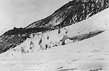
There are seven named glaciers on Mount Shasta, with the four largest (Whitney, Bolam, Hotlum, and Wintun) radiating down from high on the main summit cone to below 10,000 ft (3,000 m) primarily on the north and east sides.
[15][16] Although earlier Spanish explorers are likely to have sighted the mountain, the first written record and description was made in May 20, 1817 by Spaniard Narciso Durán, a member of the Luis Antonio Argüello expedition into the upper areas of the Sacramento River Valley, who wrote "At about ten leagues to the northwest of this place we saw the very high hill called by soldiers that went near its slope Jesus Maria, It is entirely covered with snow.
The Siskiyou Trail was on the track of an ancient trade and travel route of Native American footpaths between California's Central Valley and the Pacific Northwest.
In 1877, Muir wrote a dramatic popular article about his surviving an overnight blizzard on Mount Shasta by lying in the hot sulfur springs near the summit.
The 1887 completion of the Central Pacific Railroad, built along the line of the Siskiyou Trail between California and Oregon, brought a substantial increase in tourism, lumbering, and population into the area around Mount Shasta.
In the early 20th century, the Pacific Highway followed the track of the Siskiyou Trail to the base of Mount Shasta, leading to still more access to the mountain.
Today's version of the Siskiyou Trail, Interstate 5, brings thousands of people each year to Mount Shasta.
From February 13–19, 1959, the Mount Shasta Ski Bowl obtained the record for the most snowfall during one storm in the U.S., with a total of 15.75 feet (480 cm).
Skell fought with Spirit of the Below-World, Llao, who resided at Mount Mazama by throwing hot rocks and lava, probably representing the volcanic eruptions at both mountains.
[26] Italian settlers arrived in the early 1900s to work in the mills as stonemasons and established a strong Catholic presence in the area.
[27] Mount Shasta has also been a focus for non-Native American legends, centered on a hidden city of advanced beings from the lost continent of Lemuria.
In 1931, Harvey Spencer Lewis, using the pseudonym Wishar S[penle] Cerve,[29][30] wrote Lemuria: the lost continent of the Pacific, published by AMORC, about the hidden Lemurians of Mount Shasta that cemented the legend in many readers' minds.
[28] In August 1987, believers in the spiritual significance of the Harmonic Convergence described Mount Shasta as one of a small number of global "power centers".
They described what they saw as a man “stocky as Hulk Hogan, with leathery wings fifty feet from one end to the other and the face of a bat.”[34] Despite the conflicting details, both accounts have been added to the legend of Batsquatch as additional proof.
Over time, an ancestral Mount Shasta stratovolcano was built to a large but unknown height; sometime between 300,000 and 360,000 years ago the entire north side of the volcano collapsed, creating an enormous landslide or debris avalanche, 6.5 cu mi (27 km3)[37] in volume.
Lavas from the Sargents Ridge vent cover the Everitt Hill shield at Mount Shasta's southern foot.
Diller Canyon (400 ft or 120 m deep and 0.25 mi or 400 m wide) is an avalanche chute that was probably carved into Shastina's western face by these flows.
The rock at the 600-foot-wide (180 m) summit crater has been extensively hydrothermally altered by sulfurous hot springs and fumaroles there (only a few examples still remain).
Although geophysically quiet, periodic geochemical surveys indicate that volcanic gas emanates from a fumarole at the summit of Mount Shasta from a deep-seated reservoir of partly molten rock.