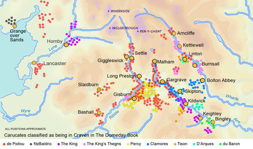
Craven District
[2] The population of the Local Authority area at the 2011 Census was 55,409;[1] it comprised the upper reaches of Airedale, Wharfedale, Ribblesdale, and includes most of the Aire Gap and Craven Basin.
[9] The first datable evidence of human life in Craven is ca 9000 BC: a hunter's harpoon point carved out of an antler found in Victoria Cave.
The valley woodlands were inhabited by deer, boar and aurochs, the higher ground was open grassland that fed herds of reindeer, elk and horse.
Lithic analysis can identify their quarry source as Langdale in central Cumbria and most finds are in Ribblesdale and Airedale indicating that Craven was their trade route through the Pennines.
[10] Neolithic farmers permanently settled in Craven, bringing domesticated livestock and used those stone axes to clear woodlands, probably by slash-and-burn, to increase areas for grazing[10] and crops.
The Wapentakes of Staincliffe and Ewcross covered the region we call Craven but also areas beyond it such as the Forest of Bowland in Lancashire; and Sedbergh in Cumbria to the North.
The Book included lands further west than any later description: Melling, Wennington and Hornby[18] on the River Lune in Lonsdale and even Holker near Grange over Sands in Cumbria.
However the opposing faction proposes that the first Yorkshire was smaller, much as it was up till 1974, and that Amounderness, Cartmel, Furness, Kendale, Copeland and Lonsdale were attached to it in the Domesday Book merely for administrative convenience.
Most of Craven is uncultivable moorland and the valley bottoms are usually boggy, shady frost-hollows, with soils of glacial boulder clay very heavy to plough.
Young King Richard II had commanded that poll tax to pay off the debts he had inherited from the Hundred Years' War.
Under its terms each liable householder was to pay one shilling for each hearth within their property, due twice annually at the equinoxes, Michaelmas (29 September) and Lady Day (25 March).
[30] “The famous monasteries under the steep, wooded banks of Yorkshire dales began the movement that in the course of four or five hundred years converted most of North England and Scotland from unused wilderness into sheep-run.”Fountains Abbey strongly affected Craven in upper Wharfedale, Airedale and Littondale.
[10]: 95 Feudal Lords began to imitate monastic management methods for their own estates[30]: 95 and in 1350 when the Black Death killed off half the rent-paying farmers they had the bailiffs substitute sheep-pasture for tillage.
[10]: 61 By 1600 the wool trade was the primary source of tax revenue for Queen Elizabeth I. Britain's success made it a major influence in the development and spread of sheep husbandry worldwide.
In more modern times the Industrial Revolution brought factory production of wool cloth to towns further down Airedale and many Craven families, made redundant by agricultural machinery, moved south to work in the worsted mills.
Palynology indicates the decline in trees coincided with the increase in grasses in Neolithic times caused by direct clearance for pasture and by overgrazing.
Some graziers of the Craven highlands also visited Scotland, for example Oban, Lanark and Stirling, to purchase stock to be brought down the drove roads to the cattle-rearing district.
In the summer of 1745 the celebrated Mr Birtwhistle had 20,000 head driven from the northernmost parts of Scotland to Great Close near Malham,[37]: 53 a distance of ca 300 miles (483 km).
In 1818 the Craven Heifer, bred for meat on the Bolton Abbey estate remains to this day the largest and fattest cow of her age ever shown in England, weighing 2,496 lb (1,132 kg).
[38] In modern times dairy farming has predominated and after the 1970s Holstein Friesians became the most popular breed[39] weighing ca 1600 pounds (725 kg).
"[10]: 47 Cultivation lynchet terraces and ridge-and-furrow fields of the Middle Ages are visible alongside many villages particularly in Wharfedale and Malhamdale[10]: 69 and tithe records show they grew crops of oats, barley and wheat[37]: 21 and in rotation, beans and peas.
In the 18th century miller's records show they had to import wheat to grind and sell as flour[37]: 21 but the farmers still grew oats for it formed the principle article of their subsistence, some made into bread and puddings[40] but mostly cooked as oatcakes.
Average wages then paid to employees were 12 pounds per annum with victuals and drink; and to temporary labourers 2 shillings and sixpence per day with beer.
[42] In July 2021 the Ministry of Housing, Communities and Local Government announced that in April 2023, the non-metropolitan county of North Yorkshire would be reorganised into a unitary authority.
The Church of England has considered changing their boundary of Bowland to match that of civic Lancashire[64] The Deanery of South Craven is much bigger than the council election division of South Craven, as the Deanery of South Craven comprises the following parishes: Cononley, Cowling, Cross Roads cum Lees, Cullingworth, Denholme, East Morton, Harden, Haworth, Ingrow, Keighley (St Andrews), Kildwick, Newsholme, Oakworth, Oxenhope, Riddlesden, Silsden, Steeton with Eastburn, Sutton-in-Craven, Thwaites Brow, Utley and Wilsden.
At the end of the last ice age, ca 11,500 years ago, plants returned to the bare earth and archaeological palynology can identify their species.
[10] “In digging it away they frequently find vast fir trees, perfectly sound, and some oaks...”Vegetation in the Pennines is adapted to subarctic climates, but altitude and acidity are also factors.
The route now known as the A56—-M65 first developed c. 1773–1816 as the Leeds and Liverpool Canal to carry heavy industrial goods like masonry stone, limestone, and coal.
By 1840 passenger stagecoaches ran daily[94] but in 1878 Parliament abolished all Turnpikes and set up County Councils; and the management of the main roads was transferred to them.
[95] The proportion of the working age population with high levels of educational attainment is above the national average, and 40% of the District's residents have managerial and professional occupations.