Crime hotspots
Clark & Evans (1954) proposed a formula that would measure the spacing between plants and animals in a population that have a random distribution.
[7] NNI compares observed distances between each point on a map and its nearest neighbor, or in other terms between each crime incident.
Bate's original formula did not answer if the "hot circle" represented an area that clearly had a higher density of crime incidents or not.
Ellipses create a firm boundary for the data set that does not necessarily follow streets or neighborhood outlines.
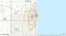
[7] A study that uses nearest neighbor index (NNI), and STAC Ellipses was completed for the City of Roanoke, Virginia.
concluded that the data set has significant global spatial clustering that applies to the entire study population.
To create the ellipses, parameter settings were made based on the distance a person can travel on foot in approximately five minutes before looking for another form of transportation.
Van Patten, McKeldin-Coner & Cox (2009) concluded in this study that all methods utilized converge around the same areas of the city.
Areas that contain crime generators would require more strategic approaches by police to make an impact.
Many social groups asked the Community Safety Project to analyze relationships between alcohol selling establishments and crime in the city.
In order to examine the concentration of liquor establishments and crime incidents, STAC ellipses were utilized.
This study further examined the statistics of crime related to liquor establishments by dissecting the number of each category that were included in each ellipse.
It was determined that crimes of homicide were typically committed in low-income areas of the city that were not located near the liquor establishment hotspots.
The following section will examine criticisms in the area of spatial analysis and the crime mapping of hotspots in a broad sense.
Ratcliffe (2002) describes potential risks and problems that arise with the use of spatial analysis and crime mapping.
Further, the impact of poverty, racism, are not included into crime mapping leading to this factor not being considered and individual peace officers bringing their own vices, judgement calls into the process.
Crime is not a mythical construct, it has tangible root causes that range from financial poverty, to biological causes (hormonal imbalances, etc.)
[17] Other issues regarding crime mapping also include interpretation and applications of different spatial analysis tools.
Eck et al. (2005) state that when using this method, other spatial analysis tools should be employed like Moran's I or Geary's C statistic.
Ratcliffe (2002) explains that victims of crimes and even sometimes offenders do not necessarily want their information portrayed to the public.
He explains this using an example of a victim of burglary, stating they would not want their information and location online for public viewing because it could potentially advertise that their property is vulnerable.
Local community groups assisted police by informing the public of the crime problems in the area.
The police department also began utilizing spatial analysis to plot crime patterns, like the one in this study.
[12] This study gave police enforcement the tools and knowledge to begin their own crime analysis unit that is still being utilized today.
During this same time period, the Chicago Police Department and the Illinois Criminal Justice Information Authority completed another study.
The purpose of the study was to help police identify which high-risk neighborhoods have high rates of homicide and gang-related violence.
The study examined a twenty-three square mile area of Chicago that contained almost twenty percent of the 1864 murders from the years 1991–992.
The "Early Warning System" is continually updated to analyze crime patterns and has been placed on GeoArchives for other departments to use.
They have also created a team to monitor and supervise 200 known gang members, and also gives them access to education, jobs, and social services.
The same study suggests that police departments should invest in patrolling hotspots for maintaining crime prevention programs.