Cross Bronx Expressway
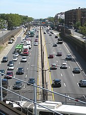
The highway experiences severe traffic problems, and its construction has been blamed for negatively affecting a number of low-income neighborhoods in the South Bronx.
[2] The Cross Bronx Expressway begins at the eastern end of the Alexander Hamilton Bridge, officially designated as both I-95 and US 1.
The highway soon intersects with Webster Avenue at a partial interchange allowing eastbound vehicles to exit and westbound ones to enter.
About 1.5 miles (2.4 km) later, the expressway has a pair of closely spaced interchanges for NY 895 (Sheridan Boulevard) and the Bronx River Parkway.
A "Cross-Bronx Route" along 161st and 163rd Streets was one of two proposed facilities, along with the "Nassau Boulevard" (which became the Long Island Expressway), picked by borough engineers as examples of important projects.
The cost was estimated at $17 million, higher than most improvements because of the "topographical conditions, high land values, and heavily built-up areas".
[16] The New York City Council adopted a resolution the next month, asking the Board of Estimate to delay the relocations,[17] which were scheduled to start that June.
[37] The state government hired the J. Kaufman Demolition Company in 1951 to raze structures on the right-of-way east of the Bronx River Parkway.
[15] The construction of this section required excavating underneath the Parkchester station of the New York City Subway's Pelham Line.
[29][28] The section from the Bronx River Parkway to the Bruckner Interchange opened on November 5, 1955, at the same time as parts of the Queens Midtown and Major Deegan expressways.
[39][1] The segment was six lanes wide;[40] its original western end was at Rosedale Avenue, where ramps connected to the northbound Bronx River Parkway.
[41] A one-mile (1.5 km) western extension from the Bronx River Parkway to a temporary interchange at Longfellow Avenue, near Boston Road, opened on April 23, 1956.
Under Lyons's plan, the highway would curve slightly southward and run along the northern edge of Crotona Park, creating a "kink" in the routing.
[64] In November 1954, the Board of Estimate voted unanimously to buy land for the section between Anthony and Longfellow Avenues, despite continued opposition from Bronx residents.
[78][79] Originally, there had not been any plans to construct an interchange with the Major Deegan Expressway, at the highway's western end, because of the area's steep topography and limited space.
[80][81] Plans for the western end of the expressway were modified substantially[82] after the Port Authority of New York and New Jersey announced in 1957 that it would construct a lower deck on the George Washington Bridge.
[89][90] (Cross Bronx traffic passing through to the Throgs Neck Bridge had been able to avoid the circle, but drivers taking the Bruckner in either direction, including those bound for New England, had to exit onto the surface.
[92][93] The following June, the New York state and city governments began hosting meetings with local residents to determine how to reconnect neighborhoods that had been split during the expressway's construction.
[94] The state government planned to finalize the designs for the five new bridges by late 2024; at the time, the project was scheduled to take four years.
Several environmental groups objected to the bridge replacement, saying that the state government had not solicited enough feedback from local residents.
In Robert Caro's The Power Broker, the author argues that Moses intentionally directed the expressway through this neighborhood, even though there was a more viable option only one block south.
[98] Many of the neighborhoods it runs through have been continually poor since its construction, partly due to the lowered property value caused by the expressway.
[102] To decrease emissions from the Cross Bronx Expressway, community activists proposed constructing a freeway lid in the early 2020s.
[103][104] The expressway is one of the main routes for shipping and transportation through New York City due to its connections with New Jersey via the George Washington Bridge, Long Island via the Throgs Neck and Whitestone Bridges, Upstate New York via I-87 northbound and the Bronx River Parkway, Manhattan via I-87 southbound to the Robert F. Kennedy Bridge or the Trans-Manhattan Expressway (extension of the Cross Bronx Expressway westward) and the Henry Hudson Parkway, and New England via the New England Thruway (I-95) and the Hutchinson River Parkway.
Proposals have been made to make dedicated truck lanes, add express bus service, and build decking on the open trenches to allow for parks, although to no avail.
[108][109] A 2002 study by the New York State Department of Transportation found that the expressway also had short entrance and exit ramps, poor sightlines, and dim lighting.
[98][110] After congestion pricing was enacted in 2025, traffic on the Cross Bronx Expressway increased as well, leading to concerns that the toll would worsen already-high levels of air pollution.