Cuando River
Some 10,000 years ago, the Cuando merged with the Okavango River and they flowed south to Lake Makgadikgadi (which is a seasonal wetland in current times[6]), but the land in that area was uplifted.
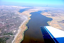
In years when the Okavango experiences a good flood some of the water escapes east along the normally dry channel of the Magwekwana River (also known as Selinda Spillway) into the Linyanti Swamp, thus entering the Zambezi basin.
On the north side of the Chobe River are the Caprivi Swamps, on the edge of which is the ruined capital of the Kololo people who conquered Barotseland in the 19th century.
So much of the water of the Cuando, Linyanti and Chobe is lost to evaporation in the various swamps that its contribution to the flow of the Zambezi is very small except in occasional years when it floods excessively.
Some of these suffered poaching during wars and conflict in Namibia and Angola, but with peace restored in those countries they have the chance of returning to their former state.