Cumberland, Maryland
Because of its strategic location on what became known as the Cumberland Road through the Appalachians, after the American Revolution it served as a historical outfitting and staging point for westward emigrant trail migrations throughout the first half of the 1800s.
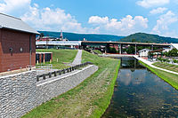
It also became an industrial center, served by major roads, railroads, and the Chesapeake and Ohio Canal, which connected Cumberland to Washington, D.C. and is now a national historical park.
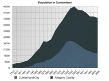
Industry declined after World War II, leading urban, business, and technological development in the state to be concentrated in eastern coastal cities.
Cumberland also served as an outpost of Colonel George Washington during the French and Indian War, and his first military headquarters was built here.
Washington returned as President of the United States in 1794 to Cumberland to review troops assembled to thwart the Whiskey Rebellion.
[7] In the 1850s, many black fugitives reached their final stop on the Underground Railroad beneath the floor of the Emmanuel Episcopal Church.
A maze of tunnels beneath and an abolitionist pastor above provided refuge before the final five mile trip to freedom in Pennsylvania.
[8] The surrounding hillsides were mined for coal and iron ore, and harvested for timber that helped supply the Industrial Revolution.
With the restructuring of heavy industry in the Northeast and Mid-Atlantic states following World War II, the city lost many jobs.
[7] The canal's towpath is maintained, allowing travel by foot, horse or bicycle between Cumberland and Washington, D.C., a distance of approximately 185 miles (298 km).
In recent years, a separate trail/path extension, called the Great Allegheny Passage, has been developed that leads to Pittsburgh as its western terminus.
Cumberland is the only city of at least 20,000 residents, outside of the Pittsburgh and DC metro areas, that lies on this combined 300+ mile stretch.
[11] Cumberland lies at the beginning of the transition from a humid continental climate (Köppen Dfa) to a humid subtropical climate (Cfa), although bearing far more characteristics of the former, with a range of temperatures significantly lower than those in the central and eastern part of Maryland, mostly in the form of depressed nighttime lows.
[17] In July 2007, The Washington Post writer Stephanie Cavanaugh wrote that the great quality of living in Cumberland had attracted many urbanites to the area.
Plants such as Pittsburgh Plate Glass, Allegany Munitions and Celanese closed down and relocated as part of widespread industrial restructuring after WWII.
[20] Located in Cumberland's arts and entertainment district is Saville Gallery, the Allegany Museum, the Cumberland Theatre, the Arts at Canal Place Cooperative Gallery, the New Embassy Theatre, the Cumberland Music Academy, MettleArts Studio and Foundry, the Arteco Gallery and Institute for Creative Enterprise, Windsor Hall, the Gilchrist Museum of the Arts, the Gordon-Roberts House, the Graphicus Atelier print-making studio, and a variety of retail and specialty stores.
Seasonal events include the Cumberland Comes Alive music series, Saturday Arts Walks, and the annual Mountain Maryland Artists' Studio Tour.
Inventor Frederick John Bahr bought Wills Mountain and built his log cabin on top.
The National Road (U.S. Route 40) and a number of railroad lines pass through this steep, narrow, and rocky river valley on the edge of Cumberland.
Lover's Leap has been frequently romanticized by postcard pictures of this valley, including those taken by George Steward in 1950 and published in the 1953 book U.S. 40.
Lover's Leap is 1,652 feet (504 m) above sea level and made up of oddly squared projections of rock, from its top, all the way down to the National Highway (U.S. Rte.
Considered the elite residential area when the city was at its economic peak, Washington Street was home to the region's leading citizens including the president of the C&O Canal.
It features Gothic Revival architecture with three large Tiffany windows, fort tunnels, and ammunition magazine cellars.
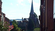
[23] The 1850 Emmanuel Episcopal Church, standing at the eastern end of the Washington Street Historic District, is one of Maryland's most outstanding examples of early Gothic Revival architecture.
Cumberland's current mayor is Ray Morriss, who was elected in 2018 after defeating two-term incumbent Brian Grim.
Some students residing in the North End of Cumberland may attend Northeast Elementary School, which sits just outside city limits in the neighborhood of Bowmans Addition.
The primary public transportation in the City of Cumberland is bus service provided by Allegany County Transit.
This service consists of five scheduled routes that reach most areas of the city and provide access to most public facilities.
The Cumberland Amtrak Station is located downtown at Queen City Drive and East Harrison Street.
The Western Maryland Scenic Railroad operates steam and diesel excursion trains from Cumberland to Frostburg and back.