Cumbre Vieja tsunami hazard
The island of La Palma in Spain is at risk of undergoing a large landslide, which could cause a tsunami in the Atlantic Ocean.
Volcanic islands and volcanoes on land frequently undergo large landslides/collapses, which have been documented in Hawaii for example.
[5] A number of such landslides have been identified in the Canary Islands, especially in the more active volcanoes El Hierro, La Palma and Tenerife[6] where about 14 such events are recorded through their deposits.
[7] They mostly take the form of debris flows[6] with volumes of 50–200 cubic kilometres (12–48 cu mi)[7] that emanate from an amphitheatre-shaped depression on the volcanic island and come to rest on the seafloor at 3,000–4,000 metres (9,800–13,100 ft) depth.
[10] Mechanisms that destabilize volcanic edifices to the point of collapse include inflation and deflation of magma chambers during the entry of new magma, intrusion of cryptodomes and dykes, and instability of slopes under loading from lava flows and oversteepened lava domes.
[22] Prehistoric landslides that caused tsunamis include the Storegga slide 8,200 years ago, a 3,000 cubic kilometres (720 cu mi) submarine landslide off Norway that generated a tsunami recorded from geological evidence in the Faroe Islands, Norway and Scotland.
[23] Another landslide-induced tsunami inundated Santiago, Cape Verde, 73,000 years ago after a collapse of the neighbouring Fogo volcano.
[29] The term "megatsunami" has been defined by media and has no precise definition, although it is commonly taken to refer to tsunamis over 100 metres (330 ft) high.
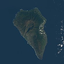
[33] During the Holocene volcanic activity on Cumbre Vieja has become concentrated along a north–south axis, which may reflect an incipient detachment fault under the volcano.
[35] Unlike on Hawaii, flank movements at Canary Islands appear to occur mainly during volcanic episodes.
Apart from fault lines, submarine volcanoes such as Kick'em Jenny and landslides are sources of tsunamis in the Atlantic.
[37][38] Ward and Day 2001 estimated that the unstable part of Cumbre Vieja would be at least 15 kilometres (9.3 mi) wide in north–south direction.
In light of the behaviour of other documented sector collapses such as at Mount St. Helens, the headscarp of the unstable part of Cumbre Vieja is likely 2–3 kilometres (1.2–1.9 mi) east from the 1949 fault[1] and the toe of the sector lies at 1–3 kilometres (0.62–1.86 mi) depth below sea level.
They had not enough information with which to estimate the thickness of the block but assumed that it would have a volume of about 150–500 cubic kilometres (36–120 cu mi) and the shape of a wedge, comparable to the Cumbre Nueva giant landslide 566,000 years ago also on La Palma.
They suggested that traces of past such tsunamis may be found in the southeastern United States, on the continental shelf, in northeast Brazil, in the Bahamas, western Africa.
[44] Gisler, Weaver and Gittings 2006 used public domain bathymetric information[3] and the so-called "SAGE hydrocode" to simulate the tsunami[45] stemming from variously shaped landslides.
[46] The waves have shorter wavelengths and periods than teletsunamis and thus do not spread as effectively as the latter away from the source[47] and decay away roughly with the inverse of the distance.
[55] In the Løvholt, Pedersen and Gisler 2008 model, the impact in the Canary Islands would be quite severe, with the tsunami reaching heights of over 10–188 metres (33–617 ft), threatening even inland valleys and towns and hitting the two largest cities of the islands (Santa Cruz and Las Palmas) badly.
They simulated inundation in Cadiz resulting from a 375 cubic kilometres (90 cu mi) collapse at La Palma.
[67] Zhou et al. 2011 used numerical simulations to model various tsunamis, including a scenario resulting from a mass failure at La Palma.
[80] The waves would take approximately one hour to propagate through the archipelago,[81] and important cities in the entire Canary Islands would be hit by substantial tsunamis irrespective of the landslide size.
[82] Tehranirad et al. 2015 modelled the impact both of a worst-case 450 cubic kilometres (110 cu mi) landslide and of a more realistic 80 cubic kilometres (19 cu mi) collapse on Ocean City, Maryland, the surrounding area, Europe, Africa and the Canary Islands, using the "THETIS"[83] and "FUNWAVE-TVD" hydrodynamical models.
[87] In the 450 cubic kilometres (110 cu mi) scenario after slightly over 8 hours from collapse tsunami waves reach the areas offshore the US coast, where their height decays as they traverse the continental shelf.
[101] Li et al. 2024 simulated a displacement of about 200 cubic kilometres (48 cu mi) of water produced by a landslide.
[105] Research by Frohlich et al. 2009 on boulders emplaced on Tongatapu endorsed the hypothesis of large landslide-induced tsunamis[106] and Ramalho et al. 2015 identified evidence of a megatsunami, implying a single step collapse, caused by the collapse of Fogo volcano in the Cape Verde islands.
[130] Return periods are not the only factor involved in estimating risk, as the amount of damage done by an extreme event has to be considered.