Cyclone Kelvin
The system was first identified as a weak tropical low on the morning of 11 February over the Northern Territory's Tiwi Islands by the Australian Bureau of Meteorology (BoM).
Additionally, the Great Northern Highway sustained infrastructural damage as a result of the heavy rainfall and flooding, cutting off access to the towns and leading to a shortage of supplies.
[1] During the morning of 11 February, the Bureau of Meteorology identified a developing tropical low pressure system near the Tiwi Islands, off the northwest coast of the Northern Territory.
[2] As the system approached the coast, the BoM began issuing warnings on it,[3] and forecast the low to potentially strengthen to a category 3 severe tropical cyclone over the following days.
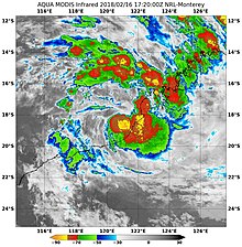
[7] Kelvin ultimately made landfall near Anna Plains Station along Eighty Mile Beach at 8:00 am AWST on 18 February as a category 3 severe tropical cyclone on the Australian scale, with 10-minute sustained winds of 150 km/h (90 mph), and a minimum central barometric pressure of 955 hPa (28.20 inHg).
[8] The system was downgraded to tropical low intensity by the BoM at 2:00 pm AWST on 19 February, after approximately 30 hours over the flat desert terrain of Western Australia.
[10][11] Unlike the BoM, the JTWC maintained the system's classification as a tropical storm for another 36 hours after this, only declaring Kelvin dissipated at 2:00 am AWST on 21 February.
[6] The remnant moisture of the system continued to track south-southeastwards across the Nullarbor Plains on 22 February,[12] and then emerged over the Great Australian Bight shortly afterward.
[13] Severe Tropical Cyclone Kelvin and its precursor low brought widespread heavy rainfall to the regions of Western Australia across which it tracked.
[17] Prior to Kelvin's landfall, as it was hugging the coast at the time, Australian authorities issued a yellow alert in the area between Broome and Pardo Roadhouse, which advised residents to take shelter as soon as possible.
[19] Two wastewater plants overflowed, causing the Water Corporation to issue bans on fishing and swimming at Roebuck Bay and Dampier Creek.
[2] In addition to the heavy precipitation, Kelvin also generated a 0.5 metre (1.6 foot) storm surge at Broome Port, and higher-than-normal ocean tides were recorded in Cable Beach.
[2] The heavy rainfall caused the already saturated water catchments in the region to overflow, and significant flooding ensued in areas such as Broome, Roebuck Plains, Logue River, Kalumburu and along the Great Northern Highway.

Tropical storm (39–73 mph, 63–118 km/h)
Category 1 (74–95 mph, 119–153 km/h)
Category 2 (96–110 mph, 154–177 km/h)
Category 3 (111–129 mph, 178–208 km/h)
Category 4 (130–156 mph, 209–251 km/h)
Category 5 (≥157 mph, ≥252 km/h)
Unknown