Cymenshore
The Latin word ōra meant "border, brim, edge, margin, end, boundary", and was used amongst other things to denote coastline.
[6] In Old English, this word had two quite different senses: "shore, foreshore" and (possibly deriving from the former meaning) "a hill shaped like an upturned canoe, featuring a long tract of flat land along the top, with a rounded shoulder at one or both ends".
[7][8] It is possible that the stretch of low ground along the coast from Southampton to Bognor was called ōra "the shore", and that district names including that word were used by the various coastal settlements, such as Ower near Southampton, Rowner near Gosport, Copnor in Portsmouth, Marker in West Thorney, Itchenor, Chalder Farm, Keynor Farm, Honer in Pagham, Bognor—and potentially Cȳmenes ōra.
[9] The account of Ælle and his three sons landing at Cymenshore in 477 appears in the common stock of the Anglo-Saxon Chronicle, a body of material compiled and composed in the ninth century, some 400 years or more after the supposed events.
[18] From the collapse of Roman administration in Britain until the embedding of Christianity among the English during the seventh century, there is a dearth of surviving written material.
[12] This lack of primary sources has made it difficult for historians to verify or disprove the Chronicle's account of Ælle's invasion.
The tradition is based largely on two charters that refer to a place with a similar name in the boundary clause to that cited in the Anglo-Saxon Chronicle.
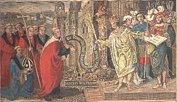
[25][26][27] The charter that defined the land award to Wilfrid at Selsey, in the 7th century, by King Caedwalla is actually a 10th-century forgery[c][25] The relevant section of the forged charter, says (in Latin): Ab introitu portus qui appellatur Anglice Wyderinges, post retractum mare in Cumeneshore, sic uersus occidentalem plagam iuxta mare usque Rumbruge, ...and the translation is: from the entrance of the harbour which is called in English Wyderinges round where the sea falls back at Cumenshore then towards the western shore at Rumbruge ...A further source is from the Charter of Byrhthelm (presumably Brihthelm, bishop of Selsey), which is believed to be genuine and is to do with some land that had been seized from the See of Selsey, it confirms that the boundary is from Wytherings Mouth[d] and Cymenshoran in the east to Hormouth in the west: Þis sinde þat land gemeare to Selesie.
Arest æt Wedering muðe, þa be sæ on Cymeneres horan, swa west be sæ oð Ðribeorgas, forð be stronde to cwuenstane 7 forð be strande on Horemuðen..These are the land-boundaries of Selsey, firstly at Withering,[d] thence by sea to the Owers, west by sea to Rumbridge; on by beach to queen's stone and on by beach to Hormouth..Rumbruge/Rumbridge (alias "thri beorg" – three barrows, now the Medmerry Bank) is believed to have been an islet and trading port off the southwest coast of the Manhood Peninsula, that has long since succumbed to the sea and Wytherings mouth was part of what is now Pagham Harbour.
For example in his Britannia Camden said: Cissa: who beeing of the Saxons line the second king of this pety kingdom, after his father Aella, accompanied with his brother Cimen and no small power of the Saxons, at this shore arrived and landed at Cimonshore, a place so called of the said Cimen, which now hath lost the name; but that it was neere unto Wittering, the charter of the donation which King Cedwalla made unto the Church of Selsey most evidently prooveth.
[48][50] Welch believes that the location for Cymenshore is more likely to be in the Ouse-Cuckmere area of East Sussex, his reasoning is that there is no archaeological evidence to support a landing at Selsey.
[51] However Richardson states that the place names with the Old English ora element of Cymensora are very common along the Hampshire and West Sussex coastline but not around the Ouse-Cuckmere area.
[j] Shoreham has also been cited as a possible location, for example in 1906 Hilaire Belloc in his Hills and the Sea when discussing St Wilfrid he said: But those memories were getting worse and worse, for it was nearly two hundred years since the ships of Ælle had sailed into Shoreham, which showed him to be a man of immense determination, for it is a most difficult harbour, and there were then no piers and lights – it was nearly two hundred years, and there was only the least little glimmering twilight left of the old day.Towards the end of the Roman occupation of England, raids on the east coast became more intense and the expedient adopted by Romano-British leaders was to enlist the help of mercenaries to whom they ceded territory.
[55] The Anglo Saxon Chronicle claims that Ælle and his forces landed at Cymenshore and then travelled east and arrived at Beachy Head in 485, where they apparently broke through an agreed river border, the Mercreadesburne.