Southern region (Eritrea)
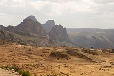
The highest point in Eritrea, is Mount Soira 3,018 m (9,902 ft), is located in the region, situated east of Senafe.
It shares borders with Central region in the north, Northern Red Sea in the east, Gash Barka in the west and Ethiopia in the south.
This region has an area of around 8,000 square kilometers, and its capital is Mendefera (Adi Ugri).
The highest point in this region, and in Eritrea, is Mount Soira 3,018 m (9,902 ft), situated east of Senafe.
The General Fertility Rate (GFR), defined as the births per 1,000 women between the ages of 15 and 45 remained at 172.0.
The Infant Mortality Rate (IMR), defined as the number of deaths of children for every 1,000 born was 58.0 while the Child Mortality Rate (CMR), defined as the number of child deaths for every 1,000 children 5 years of age was 56.0.
The number of children with the prevalence of Acute Respiratory Infection (ARI) was 1811, fever was 1811, and Diarrhea was 1811.
[5] As of 2002, the number of males completing or attending highest level of schooling in the region was 4,105 while it was 5,417 females.
Eritrea has a one party national Assembly governed by People's Front for Democracy and Justice (PFDJ) (originally Eritrean Liberation Front), From the time of independence since 30 May 1991, the country has been continuing with a transitional government elected during the elections in April 1993.
No parties or groups other than PFDJ are allowed to contest and the elections are presided by representatives from PDFJ.