Dents du Midi
Overlooking the Val d'Illiez and the Rhône valley to the south, they face the Lac de Salanfe, an artificial reservoir, and are part of the geological ensemble of the Giffre massif.
The Dents du Midi are accessible from Champéry, les Cerniers, Mex, Salvan and Vérossaz, but they have only been climbed since the end of the 18th century.
[5][6] The name "Dents du Midi" ("teeth of south") seems to come from the fact that during the 20th century, the inhabitants of the Val d'Illiez used the massif to tell the time.
This theory is supported by the old name of the Dent de Bonavau, to the south-east, which was called "Dent-d'une-heure" ("tooth of one o'clock") on maps published in 1928.
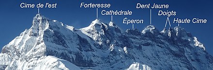
The ridge of the chain is situated at an altitude varying between 2,997 and 3,258 meters (9,833 and 10,689 ft); it is visible from Montreux, 30 kilometers (19 mi) to the north, as well as from the whole of the Rhône plain of the Chablais vaudois.
They represent the frontal hinge of the Morcles nappe, which extends to the south-west and includes Mont Joly and the Aravis mountain range in Savoie and Haute-Savoie.
In 1925, the eastern face of the Cime de l'Est collapsed; landslides reached the Bois Noir region in Saint-Maurice over several days, destroying roads and the town's water supply system.
[20] The last major landslide took place in 2006: 1,000,000 cubic meters (1,300,000 cu yd) of rock broke away from the Haute Cime on the northern slope.
The most representative nearby station is the one on the Rosa Plateau, located 65 kilometers (40 mi) to the south-east at an altitude of 3,440 meters (11,290 ft).
[22] The Dents du Midi act as a dam against the air masses coming from the northwest, creating precipitation around the peaks and over the villages of the Val d'Illiez.
The rare plants that grow here are Bavarian gentians (Gentiana bavarica), snow willow (Salix reticulata) and Ranunculus alpestris.
[27][28] The Val d'Illiez has been inhabited since ancient history, but it was not until the end of the 18th century that the first recorded ascents of the Dents du Midi were made.
[31] Ten years later, on August 16, 1842, an expedition led by Nicolas Délez and including canon Bruchon of Saint-Maurice Abbey and four other people made the first ascent of the Cime de l'Est.
Having set off from the mountain pasture of Salanfe, canon Bruchon declared in a text for the Gazette du Simplon that he had gone through "a thousand difficulties" to reach the summit, but described the view as "the most ravishing spectacle".
[35] In 1942, the Alpine Club of Saint-Maurice celebrated the centenary of the first ascent of the Cime de l'Est by erecting a metal cross at the top of the tooth.
[36] On December 23, 1970, the guides Werner Kleiner and Marcel Maurice Demont made the first winter ascent of the Cime de l'Est, the Forteresse and the Cathédrale.
[38] In 1981, Engel and Diego Bottarel, also a ski teacher, attempted to reach the summit of the Haute Cime in a hot air balloon and then descend the Couloir des Doigts.
The "trail des Dents du Midi", a foot race created in 1961 by Fernand Jordan, took place every year in mid-September between 1963 and 2000, and restarted in 2011.
[41] This 42.5 kilometers (26.4 mi) footpath offers a total difference in height of 6,000 meters (20,000 ft) and is accessible from Champéry, les Cerniers, Mex, Salvan and Vérossaz.
[43] Access to the summits of the Dents du Midi is possible in summer in the form of a trek and in winter by ski touring or mixed climbing.
[44] The normal route to the Cime de l'Est starts from the Dents du Midi refuge (2,884 metres; 9,462 ft), on the southern face, crossing the Plan Névé glacier.
About a hundred metres after the Cime de l'Est pass, which is no longer used because it is blocked by scree, it climbs a mountainside, either by taking the Rambert couloir, which may be snow-covered, or by going around it.
It starts from the Chalin hut on the northern face, joins the mountain pasture of the same name and climbs the ridge of Soi before arriving in the Forteresse-Cathédrale corridor.
Outside the Val d'Illiez, the villages of Bex, Gryon and Leysin also used the relief of the Dents du Midi in their promotional material, as did certain hotels on the Swiss shores of Lake Geneva.
These areas of 4 hectares (48,000 sq yd) each were classified in 2017 with the aim of protecting Switzerland's dry meadows and pastures from agricultural use, almost 95% of which have disappeared since 1900.
[52] They are also described or mentioned by Étienne Pivert de Senancour in Oberman (1804), Alexandre Dumas in Impressions de voyage en Suisse (1834), Eugène Rambert in Les Alpes suisses (1866) and Bex et ses environs (1871), Émile Javelle in Souvenirs d'un alpiniste (1886), Maurice Bonvoisin in La vie à Champéry (1908) and finally Charles Ferdinand Ramuz in La guerre dans le Haut-Pays (1915) and Vendanges (1927).