Depsang Bulge
[5] The area is immediately to the south of the Depsang Plains and encloses the basin of the Burtsa Nala (or Tiannan River, Chinese: 天南河), a stream originating in the Aksai Chin region and flowing west to merge with the Depsang Nala near the village of Burtsa in Ladakh, eventually draining into the Shyok River.
[6] Since 2013, China has made attempts to push the Line of Actual Control further west into Indian territory, threatening India's strategic road.
[8] All the streams bring snow-melt water, reaching the highest volume in the afternoons, and diminishing to practically nothing at other times.
Numerous tributary streams from the surrounding hills drain into the Burtsa Nala within the Depsang Bulge.
[f] Prior to the 1962 war, the Indian Army had established half a dozen posts on the hills to the north of the Depsang Bulge.
More detailed maps of the ceasefire line show a smaller bulge in Indian territory at the mouth of the valley.
A fourth line was contained in a map attached to a letter written by the Chinese premier Zhou Enlai to heads of certain non-aligned countries (or "African and Asian nations") in the midst of the 1962 war.
[27] Along with it, numerous improvements to the border infrastructure in Aksai Chin also became visible, increasing the pressure on the LAC.
[28] An existing road to the Heweitan military base (roughly at the head of the Jeong Nala) was improved and extended to join the Tianwendian Highway in the north.
This new strategic road, labelled "Tiankong Highway", ran immediately next to the Depsang Bulge in the east.
The air strip at Daulat Beg Oldi (DBO), at the northern perimeter of the Depsang Plains, was reactivated in 2008, after a gap of 43 years.
The initial road did not meet the all-weather requirement, and it had to be rebuilt on an improved alignment later, but several sections of it were available for winter use by 2013.
[44] Indian ambassador in China S. Jaishankar picked up the matter with Deng Zhen Hua, the Director-General of boundary affairs in the Chinese Foreign Ministry, and asked for the incursion to be rolled back.
Around the same time, the Indian troops in the Chumar sector in southern Ladakh constructed a tin shed at their patrol point close to the LAC.
[37] At the border personnel meeting on 23 April, the Chinese officers repeated the demand and also asked for the removal of "bunkers" at Fukche (also in southern Ladakh).
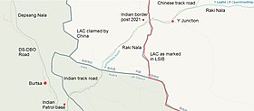
[37] After the 2013 standoff, India established a permanent post to the west of the Y-junction and bottleneck, from where Indian troops observed and stopped any Chinese patrols attempting to cross beyond that point.
As the Indian patrols attempted to go beyond the bottleneck by foot, Chinese troops were reportedly coming up in vehicles and blocking their passage.
[46][47] In order to avoid confrontation with the Chinese troops, the Indian patrols were apparently asked to not go beyond the bottleneck point.