Senkaku Islands
As a result of the dispute, the public is largely barred from approaching the uninhabited islands, which are about a seven-hour boat ride from Ishigaki.
Vessels from the Japan Coast Guard pursue Chinese ships crossing the maritime boundary in what one visiting journalist described in 2012 as "an almost cold war-style game of cat-and-mouse", and fishing and other civilian boats are prevented from getting too close to avoid a provocative incident.
[25][26][27][28] In Western sources, the historical English name Pinnacle Islands is occasionally still used when neutrality among the competing national claims is desirable.
His small library of Japanese books included Sangoku Tsūran Zusetsu (三國通覧圖說, An Illustrated Description of Three Countries) by Hayashi Shihei.
[45] A Japanese navy record issued in 1886 first started to identify the islets using equivalents of the Chinese and English terms employed by the British.
[35] The Japanese central government incorporated the islands into Okinawa Prefecture in January 1895 while still fighting China in the First Sino-Japanese War.
[38] Around 1900, Japanese entrepreneur Koga Tatsushirō (古賀 辰四郎) constructed a bonito fish processing plant on the islands, employing over 200 workers.
[48] In 1969, the United Nations Economic Commission for Asia and the Far East (ECAFE) identified potential oil and gas reserves in the vicinity of the Senkaku Islands.
[56] From 2002 to 2012, the Ministry of Internal Affairs and Communications paid the Kurihara family ¥25 million a year to rent Uotsuri, Minami-Kojima and Kita-Kojima.
[50][57] The reaction of the Kan Cabinet to the September 2010 Senkaku boat collision incident was seen by former Prime Minister Shinzo Abe as "a very foolish move" and "frighteningly naive".
[58][59] On December 17, 2010, the city of Ishigaki designated January 14 as "Pioneering Day" to commemorate Japan's 1895 incorporation of the Senkaku Islands.
[60] In May 2012, both the Tokyo Metropolitan and Japanese central governments announced plans to negotiate purchase of Uotsuri, Kita-Kojima, and Minami-Kojima from the Kurihara family,[50] and on September 11, 2012, the Japanese government nationalized its control over Minami-kojima, Kita-kojima, and Uotsuri islands by purchasing them from the Kurihara family for ¥2.05 billion.
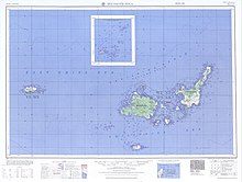
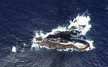
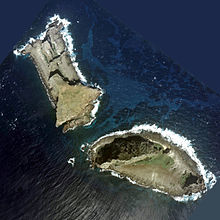
[67] According to one visitor, Uotsuri-shima, the largest of the islands, consists of a pair of rocky gray mountains with steep, boulder-strewn slopes rising almost straight from the water's edge.
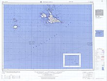
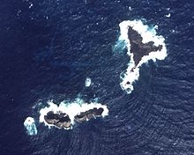
[16] In ascending order of distances, the island cluster is located: The depth of the surrounding waters of the continental shelf is approximately 100–150 metres (330–490 ft) except for the Okinawa Trough on the south.
[85] Uotsuri, Kitakojima, Minamikojima and surrounding islets are sedimentary in origin, predominantly consisting of probably Miocene aged sandstone and sandstone-conglomerate, with subordinate conglomerate, coal seams up to 10 centimetres (3.9 in) thick, and rare siltstone beds.
The sedimentary strata have around 300 metres (980 ft) of exposed thickness at Uotsuri, and have SW-NE, EW and NW-SE strikes, with a general inclination of a dip of less than 20 degrees towards the North.
[86] These strata are intruded by sheets of Mio-Pliocene porphyritic hornblende diorite, and are fringed by recent coral outcrops and surface talus deposits.
[90] In an account by Hisashi Kuroiwa [ja] in 1900, it was noted the large number of birds present on the islands, tens of thousands of short-tailed and black-footed albatross would flock on Uotsuri-shima, in the colder months, while hundreds of thousands of sooty tern and brown noddy would descend on Kitakojima and Minamikojima in the warmer months.
In the same year, an account by Miyajima Mikinosuke [ja], surveying Kuba Island, noted the presence of whimbrel, Von Schrenck's bittern, the streaked shearwater, and the brown booby.
[93] Uotsuri-shima, the largest island, has a number of endemic species such as the Senkaku mole (Mogera uchidai) and Okinawa-kuro-oo-ari ant.
[118][119] In 2016, Chinese fishing, Coast Guard and other vessels were entering the territorial waters around the islands almost daily and in August 2016 the Japanese foreign minister Fumio Kishida reportedly told China's foreign minister Wang Yi "that the activity represented an escalation of tensions" according to Japanese sources.
[124] The Taiwanese government and the opposition KMT party also condemned the council's move, saying the Islands are ROC territory and the nation would not give up even "an inch" of its sovereignty.
Reception of the film was positive in Chinese media, while the Australian Broadcasting Corporation's Correspondents Report called Nebe a 'Chinese propagandist' in 2014.