Sino-Indian border dispute
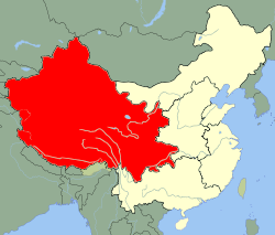
The first of the territories, Aksai Chin, is administered by China and claimed by India; it is mostly uninhabited high-altitude wasteland but with some significant pasture lands at the margins.
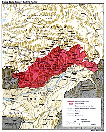
[1] It lies at the intersection of Kashmir, Tibet and Xinjiang, and is crossed by China's Xinjiang-Tibet Highway; the other disputed territory is south of the McMahon Line, in the area formerly known as the North-East Frontier Agency and now a state called Arunachal Pradesh.
A conflict involving a Bhutanese-controlled area on the border between Bhutan and China was successfully de-escalated in 2017 following injuries to both Indian and Chinese troops.
[8]: 251 Disagreements also result from the fact that the Line of Actual Control has never been distinctly demarcated, with China and India often disagreeing over its precise location.
The desolation of this area meant that it had no significant human importance other than ancient trade routes crossing it, providing brief passage during summer for caravans of yaks from Xinjiang and Tibet.
[10] The boundaries at the two extremities, Pangong Lake and Karakoram Pass, were reasonably well-defined, but the Aksai Chin area in between lay largely undefined.
The Maharajah of Jammu and Kashmir constructed a fort at Shahidulla (modern-day Xaidulla), and had troops stationed there for some years to protect caravans.
[citation needed] In 1897 a British military officer, Sir John Ardagh, proposed a boundary line along the crest of the Kun Lun Mountains north of the Yarkand River.
[citation needed] In 1893, Hung Ta-chen, a senior Chinese official at St. Petersburg, gave maps of the region to George Macartney, the British consul general at Kashgar, which coincided in broad details.
At this point the British had still made no attempts to establish outposts or control over the Aksai Chin, nor was the issue ever discussed with the governments of China or Tibet, and the boundary remained undemarcated at India's independence.
[23][24] Upon independence in 1947, the government of India fixed its official boundary in the west, which included the Aksai Chin, in a manner that resembled the Ardagh–Johnson Line.
[9] On 1 July 1954 Prime Minister Nehru wrote a memo directing that the maps of India be revised to show definite boundaries on all frontiers.
After approving a note which stated that China could not enjoy rights under the agreement unless she ratified it, the British and Tibetan negotiators signed the Simla Convention and more detailed map as a bilateral accord.
Neville Maxwell states that McMahon had been instructed not to sign bilaterally with Tibetans if China refused, but he did so without the Chinese representative present and then kept the declaration secret.
"[27] Because of doubts concerning the legal status of the accord, the British did not put the McMahon Line on their maps until 1937, nor did they publish the Simla Convention in the treaty record until 1938.
[29] The last Qing emperor's 1912 edict of abdication authorised its succeeding republican government to form a union of "five peoples, namely, Manchus, Han Chinese, Mongols, Muslims, and Tibetans together with their territory in its integrity.
"[30] However, the practice that India does not place a claim to the regions which previously had the presence of the Mauryan Empire and Chola Dynasty, but which were heavily influenced by Indian culture, further complicates the issue.
The line drawn by McMahon on the detailed 24–25 March 1914 Simla Treaty maps clearly starts at 27°45'40"N, a trijunction between Bhutan, China, and India, and from there, extends eastwards.
At the westernmost location near Bhutan north of Tawang, they modified their maps to extend their claim line northwards to include features such as Thag La ridge, Longju, and Khinzemane as Indian territory.
[38] The Indian position, as argued by prime minister Jawaharlal Nehru, was that the Aksai Chin was "part of the Ladakh region of India for centuries".
[9] In 1960, Nehru and Zhou Enlai agreed to hold discussions between officials from India and China for examining the historical, political and administrative basis of the boundary dispute.
Four members of the patrol unit were initially listed as missing before confirmation via diplomatic channels they had been killed by the Chinese troops; their bodies were later returned.
[57] In September 2014, India and China had a standoff at the LAC, when Indian workers began constructing a canal in the border village of Demchok, Ladakh, and Chinese civilians protested with the army's support.
[64][65] Following the incursion, on 28 June, the Chinese military claimed that India had blocked the construction of a road that was taking place in China's sovereign territory.
Wider overarching issues include discussion related to a package settlement versus sector-wise,[74] clarification of the LAC and border and accordingly the exchange of maps,[75] and delinking or linking the boundary dispute to other bilateral ties.
[81] In the 1980s, during the beginning of talks between the two countries, India made it clear that it would not discuss the legal position of either side as it had already been documented in the 1960 Official's report.
[5] In April 2005 another agreement mentioned that the JWG, the "India-China Diplomatic and Military Expert Group", and the "Special Representatives on the boundary question" would carry on with their work and consultations.
[105][106] In October 2024, India announced that it had reached an agreement over patrolling arrangements along the Line of Actual Control (LAC) in the border area, which would lead to disengagement and resolution of the long-running conflict that began in 2020.
Both sides have agreed on phased disengagement steps aimed at reducing tensions along the Line of Actual Control (LAC), where troops have been deployed in close proximity.
[110] Command deployment is as follows:[111] In 2024, The New York Times reported that, according to satellite imagery, China had constructed villages along and inside of disputed territory within Arunachal Pradesh.