Jiangxinpo
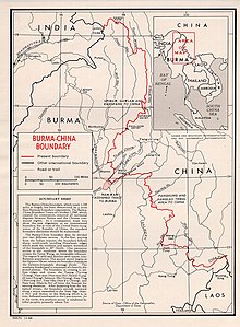
Jiangxinpo (Chinese: 江心坡) was an area currently in Kachin State, Myanmar, located between the N'Mai and Mali Rivers, west of the Gaoligong Mountains of Yunnan, China.
It was previously under the rule of the Qing dynasty of China.
In 1910, a year before Republic of China (ROC) was established, the British occupied Hpimaw[1] (片馬/片马; Piànmǎ)[2] in the Pianma Incident, as well as a part of what is now Northern Kachin state in 1926-27 and part of the Wa states in 1940.
[3][4] It was disputed territory between China and Myanmar until 1961, when People's Republic of China (PRC) recognized Myanmar's sovereignty over it,[1] with the exception of Burma relinquishing small amount of that territory,[5] namely Hpimaw (Pianma) and adjacent Gawlam (Gulang) (古浪; Gǔlàng)[6] and Kangfang[1] (崗房; 岗房; Gǎngfáng)[7] to PRC, as part of Lushui county.
Some Chinese commentators, especially those media in ROC (Taiwan)[1] and overseas which are outside the control of PRC government's censorship, criticized the PRC government for signing the agreement, which they regarded as guaranteeing the permanent loss of former Chinese territory to Myanmar.