Driver location sign
The number, although given without units, is the distance in kilometres from a designated datum location for the road, although signs meant for driver navigation are in miles.
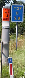
[3] On motorways distance marker posts also bear an arrow pointing towards the location of the nearest emergency telephone.
[4][6][7] Items of highway furniture are commonly uniquely identified by a code number attached to or stencilled onto them.
[9][10] The requirements for the design and implementation of driver location signs (DLS) for motorways and all-purpose trunk roads are specified in a document published by Highways England.
By the end of the 2009 financial year, 80 per cent of England's motorway network had been fitted with 16,000 driver location signs at a cost of £5.9 million (about £570 each).
[2] As of July 2009[update] driver location signs had not been erected in Scotland, Wales or Northern Ireland.
By early 2007, after experiments in the preceding four years on parts of the M25 and M6 showed a 10% improvement in emergency service response times,[2] a programme to erect driver location signs at 500-metre (550 yd) intervals on many motorways was commenced in England.
The Devon and Somerset Fire & Rescue Service reported that after a serious collision on the M5, their control centre was inundated with mobile phone calls from drivers.
[2] The analysis of an exercise run by the Highways Agency (Exercise Hermes) in which a serious traffic accident was simulated reported that call handlers in control rooms should request marker post or location sign locations when taking calls from members of the public.
The publicly available Highways Agency documentation does not cover this possibility,[16] but it will be noticed that the four carriageway identifiers "E", "F", "G" and "H" have not been allocated.