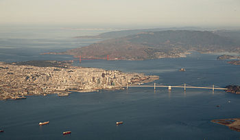
San Francisco Bay
San Francisco Bay is the second-largest estuary on the Pacific coast of the Americas, following the Salish Sea in Washington State and British Columbia, Canada.
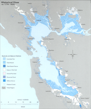
Despite its value as a waterway and harbor, many thousands of acres of marshy wetlands at the edges of the bay were, for many years, considered wasted space.
As a result, soil excavated for building projects or dredged from channels was often dumped onto the wetlands and other parts of the bay as landfill.
[citation needed] The Marina District of San Francisco, hard hit by the 1989 earthquake, was built on fill that had been placed there for the Panama-Pacific International Exposition, although liquefaction did not occur on a large scale.
Mountainous Yerba Buena Island is pierced by a tunnel linking the east and west spans of the San Francisco–Oakland Bay Bridge.
[10] The Farallon Islands are what used to be hills along the old coastline,[10] and Potato Patch Shoal is an area of sand dunes now covered by the ocean.
[12][13] The first recorded European discovery of San Francisco Bay was on November 4, 1769, when Spanish explorer Gaspar de Portolá, unable to find the Port of Monterey, continued north close to what is now Pacifica and reached the summit of the 1,200-foot-high (370 m) Sweeney Ridge, now marked as the place where he first sighted San Francisco Bay.
[citation needed] Alaskan Native sea otter hunters using Aleutian kayaks and working for the Russian–American Company entered San Francisco Bay in 1807 and again over 1810–1811.
On February 2, 1848, the Mexican province of Alta California was annexed to the United States with the signing of the Treaty of Guadalupe Hidalgo.
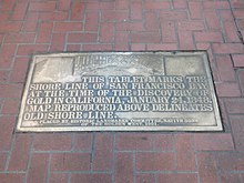
[citation needed] In 1921, a tablet was dedicated by a group of men in downtown San Francisco, marking the site of the original shoreline.
During the California Gold Rush (1848–1855), San Francisco Bay suddenly became one of the world's great seaports, dominating shipping in the American West until the last years of the 19th century.
[29] On September 17, 1965, the California State Legislature enacted the McAteer-Petris Act, which created the San Francisco Bay Conservation and Development Commission.
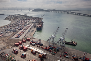
The San Francisco Bay continues to support some of the densest industrial production and urban settlement in the United States.
[30] Despite its urban and industrial character, San Francisco Bay and the Sacramento–San Joaquin River Delta remain perhaps California's most important ecological habitats.
[citation needed] Salt produced from San Francisco Bay is produced in salt evaporation ponds and is shipped throughout the Western United States to bakeries, canneries, fisheries, cheese makers and other food industries and used to de-ice winter highways, clean kidney dialysis machines, for animal nutrition, and in many industries.
Mid-salinity ponds support dense populations of brine shrimp, which provide a rich food source for millions of shorebirds.
Recent genetic studies show that there is a local stock from San Francisco to the Russian River and that eastern Pacific coastal populations rarely migrate far, unlike western Atlantic Harbor porpoise.
[38] The common bottlenose dolphin (Tursiops truncatus) has been extending its current range northwards from the Southern California Bight.
The first coastal bottlenose dolphin in the Bay Area in recent times was spotted in 1983 off the San Mateo County coast in 1983.
[39] San Francisco Bay faces many of the same water quality issues as other urban waterways in industrialized countries, or downstream of intensive agriculture.
[42] The bay also has some of the highest levels of dissolved inorganic nitrogen known from any coastal water body, mostly originating from treated wastewater from Publicly owned treatment works.
The bay was once considered a hotspot for polybrominated diphenyl ether (PBDE) flame retardants used to make upholstered furniture and infant care items less flammable.
A 2019 San Francisco Estuary Institute (SFEI) study assayed a wide range of these newer flame retardant chemicals in Bay waters, bivalve California mussels (Mytilus californianus), and harbor seals (Phoca vitulina) which haul out in Corkscrew Slough[45] on Bair Island in San Mateo County, with phosphate flame retardant contaminants such as tris(1,3-dichloro-2-propyl)phosphate (TDCPP) and triphenyl phosphate (TPhP) found at levels comparable to thresholds for aquatic toxicity.
[citation needed] In the 1860s and continuing into the early 20th century, miners dumped staggering quantities of mud and gravel from hydraulic mining operations into the upper Sacramento and San Joaquin Rivers.
GK Gilbert's estimates of debris total more than eight times the amount of rock and dirt moved during construction of the Panama Canal.
[52][53] This dredging enabled the arrival of the largest container ship ever to enter the San Francisco Bay, the MSC Fabiola.
The ship arrived drawing less than its full draft of 50 feet 10 inches (15.5 m) because it held only three-quarters of a load after its stop in Long Beach.
[citation needed] The Transbay Tube, an underwater rail tunnel, carries BART services between Oakland and San Francisco.
San Francisco Bay is popular for sailors (boats, as well as windsurfing and kitesurfing), due to consistent strong westerly/northwesterly thermally-generated winds – Beaufort force 6 (15–25 knots; 17–29 mph; 8–13 m/s) is common on summer afternoons – and protection from large open ocean swells.
The California Office of Environmental Health Hazard Assessment (OEHHA) has developed a safe eating advisory for fish caught in the San Francisco Bay based on levels of mercury or PCBs found in local species.